Courjeonnet
Courjeonnet ist eine französische Gemeinde mit 47 Einwohnern (Stand 1. Januar 2019) im Département Marne in der Region Grand Est. Sie gehört zum Kanton Dormans-Paysages de Champagne und zum Arrondissement Épernay.
| Courjeonnet | ||
|---|---|---|
| ||
| Staat | Frankreich | |
| Region | Grand Est | |
| Département (Nr.) | Marne (51) | |
| Arrondissement | Épernay | |
| Kanton | Dormans-Paysages de Champagne | |
| Gemeindeverband | Paysages de la Champagne | |
| Koordinaten | 48° 50′ N, 3° 50′ O | |
| Höhe | 139–210 m | |
| Fläche | 5,49 km² | |
| Einwohner | 47 (1. Januar 2019) | |
| Bevölkerungsdichte | 9 Einw./km² | |
| Postleitzahl | 51270 | |
| INSEE-Code | 51186 | |

Geografie
Die Gemeinde Courjeonnet liegt am Nordrand des Sumpfgebietes Marais de Saint-Gond, der von Petit Morin durchflossen wird, etwa 18 Kilometer nordöstlich von Sézanne. Sie ist umgeben von folgenden Nachbargemeinden:
| Congy | Vert-Toulon | |
| Villevenard | .svg.png.webp) |
Coizard-Joches |
| Reuves, Oyes | Broussy-le-Petit | Broussy-le-Grand |
Bevölkerungsentwicklung
| Jahr | 1962 | 1968 | 1975 | 1982 | 1990 | 1999 | 2008 | 2018 | |
|---|---|---|---|---|---|---|---|---|---|
| Einwohner | 66 | 67 | 66 | 50 | 65 | 61 | 52 | 47 | |
| Quellen: Cassini und INSEE | |||||||||
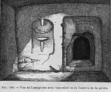
Grotte von Courjeonnet
This article is issued from Wikipedia. The text is licensed under Creative Commons - Attribution - Sharealike. The authors of the article are listed here. Additional terms may apply for the media files, click on images to show image meta data.