Brugny-Vaudancourt
| Brugny-Vaudancourt | ||
|---|---|---|
|
| |
| Staat | Frankreich | |
| Region | Grand Est | |
| Département (Nr.) | Marne (51) | |
| Arrondissement | Épernay | |
| Kanton | Épernay-2 | |
| Gemeindeverband | Épernay, Coteaux et Plaine de Champagne | |
| Koordinaten | 49° 0′ N, 3° 53′ O | |
| Höhe | 106–243 m | |
| Fläche | 19,89 km² | |
| Einwohner | 445 (1. Januar 2019) | |
| Bevölkerungsdichte | 22 Einw./km² | |
| Postleitzahl | 51530 | |
| INSEE-Code | 51093 | |
| Website | http://www.brugny-vaudancourt.fr/ | |

Brugny-Vaudancourt ist eine französische Gemeinde mit 445 Einwohnern (Stand: 1. Januar 2019) im Département Marne in der Region Grand Est. Sie gehört zum Arrondissement Épernay und zum Kanton Épernay-2. Die Einwohner werden Brugnitiers-Vaudancouriers genannt.
Lage
Brugny-Vaudancourt liegt etwa 31 Kilometer südsüdwestlich von Reims. Umgeben wird Brugny-Vaudancourt von den Nachbargemeinden Saint-Martin-d’Ablois im Norden, Vinay im Norden und Nordosten, Chavot-Courcourt im Osten und Nordosten, Morangis im Süden und Südosten, Montmort-Lucy im Süden sowie Le Baizil im Westen und Südwesten.
Bevölkerungsentwicklung
| Jahr | 1962 | 1968 | 1975 | 1982 | 1990 | 1999 | 2006 | 2011 | 2018 |
| Einwohner | 429 | 418 | 468 | 437 | 448 | 388 | 428 | 459 | 446 |
| Quellen: Cassini und INSEE | |||||||||
Sehenswürdigkeiten
- Kirche Saint-Sébastien in Brugny
- Kapelle von Vaudancourt
- Schloss Brugny aus dem 16. Jahrhundert, Monument historique seit 1990
- ehemaliges Waschhaus (Lavoir)
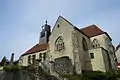 Kirche Saint-Sébastien
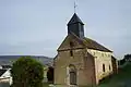 Kapelle von Vaudancourt
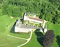 Schloss Brugny
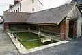
This article is issued from Wikipedia. The text is licensed under Creative Commons - Attribution - Sharealike. The authors of the article are listed here. Additional terms may apply for the media files, click on images to show image meta data.