Col du Pillon
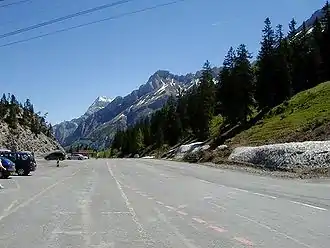
Der Col du Pillon ist ein Pass im Schweizer Kanton Waadt. Er befindet sich zwischen den Orten Les Diablerets (politische Gemeinde Ormont-Dessus) und Gsteig, die Passhöhe liegt auf 1546 m.
| Col du Pillon | |||
|---|---|---|---|
 Col du Pillon Col du Pillon | |||
| Himmelsrichtung | West | Ost | |
| Passhöhe | 1546 m ü. M. | ||
| Kanton | Waadt | Bern | |
| Talorte | Le Sépey | Gstaad | |
| Ausbau | Passstrasse | ||
| Profil | |||
| Ø-Steigung | 4,4 % (596 m / 13,6 km) | 2,9 % (496 m / 17,25 km) | |
| Max. Steigung | 9,7 % | 6,6 % | |
| Karte (Waadt) | |||
| |||
| Koordinaten | 582002 / 133593 | ||
Seit 1964 führt eine Luftseilbahn vom Col du Pillon in zwei Sektionen auf den Gipfel des Sex Rouge im Skigebiet Glacier 3000 des Diablerets-Massivs und ermöglicht auf dem Plateau des Tsanfleurongletschers von Oktober bis Mai Skisport.
Die Passstrasse ist das ganze Jahr über geöffnet.
Weblinks
Ächerli • Agites • Aiguillon • Albis • Albula • Balmberg • Benkerjoch • Bernina • Böhler • Bözberg • Breitehöchi • Brünig • Buechenegg • Bürersteig • Chall • Challhöchi • Champex • Chasseral • Chatzenstrick • Chilchzimmersattel • Croix • Croix • Croix de Coeur • Eichhöhe • Étroits • Etzelpass • Flüela • Forclaz • Furka • Ghöch • Givrine • Glas • Glaubenberg • Glaubenbielen • Gottschalkenberg • Grimsel • Grosse Scheidegg • Grosser St. Bernhard • Gurnigel • Haggenegg • Hahnenmoos • Heitersberg • Hilferen • Hirzel • Hirzel Höhi • Hulftegg • Ibergeregg • Jaman • Jaun • Julier • Kerenzerberg • Klausen • Kunkels • Lein • Lenzerheide • Livigno • Lukmanier • Maloja • Marchairuz • Mollendruz • Mont Crosin • Monte Ceneri • Mont d'Orzeires • Montvoie • Morgins • Mosses • Mutschellen • Neggia • Nufenen • Oberalp • Oberer Hauenstein • Oberricken • Ofen • Orn • Passwang • Pierre Pertuis • Pillon • Planches • Pontins • Pragel • Randenüberfahrt • Rangiers • Raten • Rengg • Ricken • Roches • Ruppen • Rüsler • Saanenmöser • Salhöhe • San Bernardino • Sanetsch • Santelhöchi • Sattel • Sattelegg • Schafmatt • Schallenberg • Schelten • Schönau • Schufelberger Egg • Schwägalp • Schwarzenbühl • Siblingerhöhe • Simplon • Splügen • St. Anton • St. Gotthard • St. Luzisteig • Staffelegg • Stoss • Susten • Tourne • Tronc • Umbrail • Unterer Hauenstein • Vorder Höhi • Vue des Alpes • Wasserfluh • Weissenstein • Wildhaus • Wissegg • Wolfgang