Autoroute A 51
Die Autoroute A 51, auch als Autoroute du Val de Durance bezeichnet, ist eine französische Autobahn mit Beginn in Marseille und dem Ende in Le Pont-de-Claix (Grenoble). Ihre Gesamtlänge beträgt 172 km.
| Autoroute A51 in Frankreich | ||||||||||||||||||||||||||||||||||||||||||||||||||||||||||||||||||||||||||||||||||||||||||||||||||||||||||||||||||||||
 | ||||||||||||||||||||||||||||||||||||||||||||||||||||||||||||||||||||||||||||||||||||||||||||||||||||||||||||||||||||||
| | ||||||||||||||||||||||||||||||||||||||||||||||||||||||||||||||||||||||||||||||||||||||||||||||||||||||||||||||||||||||
| Karte | ||||||||||||||||||||||||||||||||||||||||||||||||||||||||||||||||||||||||||||||||||||||||||||||||||||||||||||||||||||||
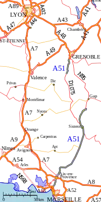 Verlauf der A 51 | ||||||||||||||||||||||||||||||||||||||||||||||||||||||||||||||||||||||||||||||||||||||||||||||||||||||||||||||||||||||
| Basisdaten | ||||||||||||||||||||||||||||||||||||||||||||||||||||||||||||||||||||||||||||||||||||||||||||||||||||||||||||||||||||||
| Betreiber: | Escota | |||||||||||||||||||||||||||||||||||||||||||||||||||||||||||||||||||||||||||||||||||||||||||||||||||||||||||||||||||||
| weiterer Betreiber: | AREA | |||||||||||||||||||||||||||||||||||||||||||||||||||||||||||||||||||||||||||||||||||||||||||||||||||||||||||||||||||||
| Gesamtlänge: | 172 km | |||||||||||||||||||||||||||||||||||||||||||||||||||||||||||||||||||||||||||||||||||||||||||||||||||||||||||||||||||||
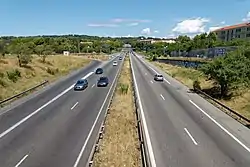 | ||||||||||||||||||||||||||||||||||||||||||||||||||||||||||||||||||||||||||||||||||||||||||||||||||||||||||||||||||||||
| Die A 51 bei Aix-en-Provence. | ||||||||||||||||||||||||||||||||||||||||||||||||||||||||||||||||||||||||||||||||||||||||||||||||||||||||||||||||||||||
Straßenverlauf
| ||||||||||||||||||||||||||||||||||||||||||||||||||||||||||||||||||||||||||||||||||||||||||||||||||||||||||||||||||||||
Geschichte
- ?. ? 1953: Eröffnung Septèmes-les-Vallons – Cabriès (A 7 – Abfahrt 2)
- 31. Dezember 1970: Eröffnung Aix-en-Provence-sud – Aix-en-Provence-Jas de Bouffan (A 8 – Abfahrt 7)
- 15. Oktober 1971: Eröffnung Cabriès – Aix-en-Provence-sud (Abfahrt 2 – A 8)
- ?. ? 1974: Eröffnung der Abfahrt Plan-de-Campagne (Abfahrt 1)
- ?. August 1978: Eröffnung Les Logissons – Venelles (Abfahrt 12–14) (1. Fahrbahn) (→ N 296)
- 20. Dezember 1984: Eröffnung Les Logissons – Venelles (Abfahrt 12–14) (2. Fahrbahn)
- 22. März 1985: Eröffnung Venelles – Mirabeau (Abfahrt 14 – F. P.)
- 12. Dezember 1986: Eröffnung Mirabeau – Manosque (F. P. – Abfahrt 18)
- 21. Dezember 1989: Eröffnung Manosque – Aubignosc (Abfahrt 18–21)
- 28. Juni 1990: Eröffnung Aubignosc – Sisteron-nord (Abfahrt 21–23)
- 26. Juni 1999: Eröffnung Sisteron-nord – La Saulce (Abfahrt 23–24)
- 29. Juli 1999: Eröffnung Claix – La Coynelle (A 480 – F. P.) Z
- 21. März 2007: Eröffnung La Coynelle – Col du Fau (F. P. – D 10 75)
Der Abschnitt zwischen der Abfahrt 8 Aix-Centre und der Abfahrt 12 Les Logissons (Ortsumgehung Aix-en-Provence) ist Teil der N 296 und nicht als Autobahn, sondern nur als Schnellstraße ausgebaut und beschildert. Allerdings sind die Ausfahrten durchgehend nummeriert.
Großstädte an der Autobahn
Weblinks
- Autoroute A 51 in deutscher und französischer Fassung des SARATLAS
- Autoroute A 51 auf WikiSara (frz.)
Portal Straßen • WikiProjekt Straßen
This article is issued from Wikipedia. The text is licensed under Creative Commons - Attribution - Sharealike. The authors of the article are listed here. Additional terms may apply for the media files, click on images to show image meta data.