Autoroute A131
Die Autoroute A 131 ist eine französische Autobahn mit Beginn in Bourneville und Ende in Le Havre. Sie hat eine Gesamtlänge von 34 km.
| Autoroute A131 in Frankreich | ||||||||||||||||||||||||||||||||||
| | ||||||||||||||||||||||||||||||||||
| Karte | ||||||||||||||||||||||||||||||||||
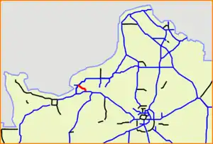 Verlauf der A 131 | ||||||||||||||||||||||||||||||||||
| Basisdaten | ||||||||||||||||||||||||||||||||||
| Betreiber: | SAPN | |||||||||||||||||||||||||||||||||
| weiterer Betreiber: | DIR Nord-Ouest | |||||||||||||||||||||||||||||||||
| Gesamtlänge: | 34,0 km | |||||||||||||||||||||||||||||||||
Straßenverlauf
| ||||||||||||||||||||||||||||||||||
Geschichte
- März 1974: Eröffnung Le Hode – Harfleur (Abfahrt RD982 – N 282), 1. Fahrbahn
- 1985: Eröffnung Le Hode – Harfleur (Abfahrt RD982 – N 282), 2. Fahrbahn
- 1985: Eröffnung Le Hode – Tancarville (Abfahrt RD982 – Pont de Tancarville)
- 1. Januar 1994: Umnummerierung Quilleboeuf-sur-Seine – Bourneville (Pont de Tancarville - A 13, aus N 182)
Weblinks
- Autoroute A131 in deutscher und französischer Fassung des SARATLAS
- Autoroute A131 auf WikiSara (frz.)
Portal Straßen • WikiProjekt Straßen
This article is issued from Wikipedia. The text is licensed under Creative Commons - Attribution - Sharealike. The authors of the article are listed here. Additional terms may apply for the media files, click on images to show image meta data.