Autoroute A 49
Die Autoroute A 49 ist eine französische Autobahn mit dem Beginn in Romans-sur-Isère und dem Ende in Voreppe. Ihre Länge beträgt insgesamt 61 km.
| Autoroute A49 in Frankreich | |||||||||||||||||||||||||||||||||||||
 | |||||||||||||||||||||||||||||||||||||
| | |||||||||||||||||||||||||||||||||||||
| Karte | |||||||||||||||||||||||||||||||||||||
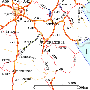 Verlauf der A 49 | |||||||||||||||||||||||||||||||||||||
| Basisdaten | |||||||||||||||||||||||||||||||||||||
| Betreiber: | AREA | ||||||||||||||||||||||||||||||||||||
| Gesamtlänge: | 61 km | ||||||||||||||||||||||||||||||||||||
 | |||||||||||||||||||||||||||||||||||||
| Die A 49 bei Valence. | |||||||||||||||||||||||||||||||||||||
Straßenverlauf
| |||||||||||||||||||||||||||||||||||||
Geschichte
- 29. Dezember 1990: Eröffnung Voreppe – Tullins (A 48 – Abfahrt 11)
- 20. Dezember 1991: Eröffnung Tullins – Bourg-de-Péage (Abfahrt 11 – N 532)
Großstädte an der Autobahn
Weblinks
- Autoroute A 49 in deutscher und französischer Fassung des SARATLAS
- Autoroute A 49 auf WikiSara (frz.)
Portal Straßen • WikiProjekt Straßen
This article is issued from Wikipedia. The text is licensed under Creative Commons - Attribution - Sharealike. The authors of the article are listed here. Additional terms may apply for the media files, click on images to show image meta data.