Autoroute A 57
Die Autoroute A 57 ist eine französische Autobahn mit Beginn in Toulon und dem Ende in Le Cannet-des-Maures. Die Autobahn hat eine Länge von 57 km.
| Autoroute A57 in Frankreich | |||||||||||||||||||||||||||||||||||||||||||||||||
 | |||||||||||||||||||||||||||||||||||||||||||||||||
| Karte | |||||||||||||||||||||||||||||||||||||||||||||||||
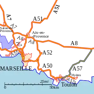
 Verlauf der A 57 | |||||||||||||||||||||||||||||||||||||||||||||||||
| Basisdaten | |||||||||||||||||||||||||||||||||||||||||||||||||
| Betreiber: | Escota | ||||||||||||||||||||||||||||||||||||||||||||||||
| Gesamtlänge: | 57 km | ||||||||||||||||||||||||||||||||||||||||||||||||
 | |||||||||||||||||||||||||||||||||||||||||||||||||
Straßenverlauf
| |||||||||||||||||||||||||||||||||||||||||||||||||
Geschichte
- ?. Dezember 1964: Eröffnung Toulon-centre - La Valette-du-Var (Tunnel de Toulon - Abfahrt 3) als N 97 bis
- ?. ? 1965: Eröffnung Solliès-Ville - Solliès-Pont (Abfahrt 7) → (N 97)
- ?. ? 1967: Umbenennung in C 52
- 4. September 1969: Eröffnung La Valette-du-Var - Les Moulières (Abfahrt 3 - 5)
- ?. ? 1970: Eröffnung Cuers-sud - Cuers-nord (Abfahrt 9 - 10) → (N 97)
- 30. April 1975: Eröffnung La Farlède - Solliès-Ville (Abfahrt 6), (1. Fahrbahn)
- 18. Juni 1976: Eröffnung Les Moulières - La Farlède (Abfahrt 5 - 6)
- 18. Juni 1976: Eröffnung La Farlède - Solliès-Ville (Abfahrt 6), (2. Fahrbahn)
- ?. ? 1982: Umbenennung in A 57
- ?. ? 1986: Eröffnung Solliès-Pont - Cuers-sud (Abfahrt 7 - 9)
- 20. Dezember 1991: Eröffnung Cuers-nord - Le Cannet-des-Maures (Abfahrt 10 - A 8)
- 28. Dezember 1991: Eröffnung Cuers-sud - Cuers-nord (Abfahrt 9 - 10)
- 21. Februar 2001: Eröffnung der Abfahrt Carnoules (Abfahrt 11)
Großstädte an der Autobahn
Weblinks
- Autoroute A 57 in deutscher und französischer Fassung des SARATLAS
- Autoroute A 57 auf WikiSara (frz.)
This article is issued from Wikipedia. The text is licensed under Creative Commons - Attribution - Sharealike. The authors of the article are listed here. Additional terms may apply for the media files, click on images to show image meta data.
