Valady
Valady (okzitanisch: Valadin) ist eine französische Gemeinde im Département Aveyron in der Region Okzitanien mit 1.593 Einwohnern (Stand: 1. Januar 2019). Die Gemeinde gehört zum Arrondissement Rodez und zum Kanton Vallon (bis 2015: Kanton Marcillac-Vallon). Die Einwohner werden Valadinois genannt.
| Valady Valadin | ||
|---|---|---|

|
| |
| Staat | Frankreich | |
| Region | Okzitanien | |
| Département (Nr.) | Aveyron (12) | |
| Arrondissement | Rodez | |
| Kanton | Vallon | |
| Gemeindeverband | Conques-Marcillac | |
| Koordinaten | 44° 27′ N, 2° 26′ O | |
| Höhe | 283–636 m | |
| Fläche | 15,43 km² | |
| Einwohner | 1.593 (1. Januar 2019) | |
| Bevölkerungsdichte | 103 Einw./km² | |
| Postleitzahl | 12330 | |
| INSEE-Code | 12288 | |
 Rathaus | ||

Geographie
Valady liegt im Weinbaugebiet Marcillac, Teil der Weinbauregion Sud-Ouest, am Fluss Ady. Umgeben wird Valady von den Nachbargemeinden Saint-Christophe-Vallon im Norden und Nordwesten, Marcillac-Vallon im Norden und Nordosten, Salles-la-Source im Osten, Druelle Balsac mit Balsac im Süden, Clairvaux-d’Aveyron im Südwesten sowie Goutrens im Westen und Südwesten.
Bevölkerungsentwicklung
| 1962 | 1968 | 1975 | 1982 | 1990 | 1999 | 2006 | 2013 |
|---|---|---|---|---|---|---|---|
| 780 | 708 | 765 | 927 | 1.014 | 1.133 | 1.380 | 1.532 |
| Quelle: Cassini und INSEE | |||||||
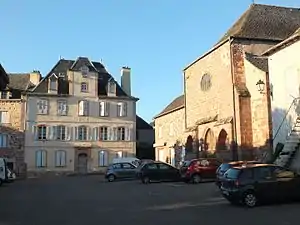
Sehenswürdigkeiten
- Kirche Saint-Pierre-ès-Liens
- Schloss Valady
- Domäne Las Canals
Weblinks
Commons: Valady – Sammlung von Bildern, Videos und Audiodateien
This article is issued from Wikipedia. The text is licensed under Creative Commons - Attribution - Sharealike. The authors of the article are listed here. Additional terms may apply for the media files, click on images to show image meta data.