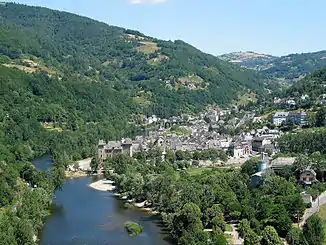
Entraygues-sur-Truyère
Entraygues-sur-Truyère ist eine Gemeinde mit 985 Einwohnern (Stand 1. Januar 2019) in Frankreich im Département Aveyron, in der Region Okzitanien. Entraygues-sur-Truyère liegt in den westlichen Ausläufern des Zentralmassivs. Der Fluss Truyère fließt durch die Stadt und mündet unmittelbar danach in den Fluss Lot. Das Gemeindegebiet gehört zum Regionalen Naturpark Aubrac.
| Entraygues-sur-Truyère | ||
|---|---|---|
.svg.png.webp)
|
| |
| Staat | Frankreich | |
| Region | Okzitanien | |
| Département (Nr.) | Aveyron (12) | |
| Arrondissement | Rodez | |
| Kanton | Lot et Truyère | |
| Gemeindeverband | Comtal Lot et Truyère | |
| Koordinaten | 44° 39′ N, 2° 34′ O | |
| Höhe | 222–744 m | |
| Fläche | 30,80 km² | |
| Einwohner | 985 (1. Januar 2019) | |
| Bevölkerungsdichte | 32 Einw./km² | |
| Postleitzahl | 12140 | |
| INSEE-Code | 12094 | |
 Ortsansicht | ||
Bevölkerungsentwicklung
| Jahr | 1962 | 1968 | 1975 | 1982 | 1990 | 1999 | 2007 | 2016 |
| Einwohner | 1582 | 1508 | 1510 | 1523 | 1495 | 1267 | 1182 | 1017 |
| Quellen: Cassini und INSEE | ||||||||
This article is issued from Wikipedia. The text is licensed under Creative Commons - Attribution - Sharealike. The authors of the article are listed here. Additional terms may apply for the media files, click on images to show image meta data.
