Tourailles
Tourailles ist eine französische Gemeinde mit 134 Einwohnern (Stand: 1. Januar 2019) im Département Loir-et-Cher in der Region Centre-Val de Loire. Sie gehört zum Arrondissement Vendôme und ist Teil des Kantons Montoire-sur-le-Loir (bis 2015: Kanton Selommes).
| Tourailles | ||
|---|---|---|
.svg.png.webp)
|
| |
| Staat | Frankreich | |
| Region | Centre-Val de Loire | |
| Département (Nr.) | Loir-et-Cher (41) | |
| Arrondissement | Vendôme | |
| Kanton | Montoire-sur-le-Loir | |
| Gemeindeverband | Territoires Vendômois | |
| Koordinaten | 47° 41′ N, 1° 10′ O | |
| Höhe | 117–134 m | |
| Fläche | 7,49 km² | |
| Einwohner | 134 (1. Januar 2019) | |
| Bevölkerungsdichte | 18 Einw./km² | |
| Postleitzahl | 41190 | |
| INSEE-Code | 41261 | |

Geografie
Tourailles liegt etwa 18 Kilometer nordwestlich von Blois. Umgeben wird Tourailles von den Nachbargemeinden Villeromain im Norden, Villemardy im Nordosten, Villefrancœur im Osten, Landes-le-Gaulois im Süden und Südosten sowie Pray im Westen.
Einwohnerentwicklung
| 1962 | 1968 | 1975 | 1982 | 1990 | 1999 | 2006 | 2017 |
| 168 | 171 | 158 | 135 | 149 | 133 | 138 | 134 |
| Quellen: Cassini und INSEE | |||||||
Sehenswürdigkeiten
- Kirche Saint-Jean
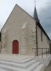
Kirche Saint-Jean
Weblinks
Commons: Tourailles – Sammlung von Bildern, Videos und Audiodateien
This article is issued from Wikipedia. The text is licensed under Creative Commons - Attribution - Sharealike. The authors of the article are listed here. Additional terms may apply for the media files, click on images to show image meta data.