Fontaine-Raoul
Fontaine-Raoul ist eine französische Gemeinde mit 234 Einwohnern (Stand: 1. Januar 2019) im Département Loir-et-Cher in der Region Centre-Val de Loire. Sie ist dem Kanton Le Perche (bis 2015: Kanton Droué) und dem Arrondissement Vendôme zugeteilt.
| Fontaine-Raoul | ||
|---|---|---|
.svg.png.webp)
|
| |
| Staat | Frankreich | |
| Region | Centre-Val de Loire | |
| Département (Nr.) | Loir-et-Cher (41) | |
| Arrondissement | Vendôme | |
| Kanton | Le Perche | |
| Gemeindeverband | Le Perche et Haut Vendômois | |
| Koordinaten | 47° 59′ N, 1° 8′ O | |
| Höhe | 124–256 m | |
| Fläche | 21,97 km² | |
| Einwohner | 234 (1. Januar 2019) | |
| Bevölkerungsdichte | 11 Einw./km² | |
| Postleitzahl | 41270 | |
| INSEE-Code | 41088 | |

Geografie
Fontaine-Raoul liegt etwa 53 Kilometer nordnordwestlich von Blois in der Landschaft Le Perche. Umgeben wird Fontaine-Raoul von den Nachbargemeinden Ruan-sur-Egvonne im Norden, Villebout im Osten, Saint-Jean-Froidmentel im Südosten, Saint-Hilaire-la-Gravelle im Süden und Südosten, La Ville-aux-Clercs im Südwesten, Chauvigny-du-Perche im Westen sowie Bouffry im Westen und Nordwesten.
Bevölkerungsentwicklung
| Jahr | 1962 | 1968 | 1975 | 1982 | 1990 | 1999 | 2006 | 2017 |
|---|---|---|---|---|---|---|---|---|
| Einwohner | 343 | 281 | 208 | 209 | 178 | 197 | 220 | 225 |
| Quelle: Cassini und INSEE | ||||||||
Sehenswürdigkeiten
- Kirche Saint-Marc
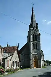
Kirche Saint-Marc
Weblinks
Commons: Fontaine-Raoul – Sammlung von Bildern, Videos und Audiodateien
This article is issued from Wikipedia. The text is licensed under Creative Commons - Attribution - Sharealike. The authors of the article are listed here. Additional terms may apply for the media files, click on images to show image meta data.