Landes-le-Gaulois
Landes-le-Gaulois ist eine französische Gemeinde mit 742 Einwohnern (Stand: 1. Januar 2019) im Département Loir-et-Cher in der Region Centre-Val de Loire. Sie gehört zum Arrondissement Blois, zum Kanton Onzain und zum Gemeindeverband Agglomération de Blois. Die Einwohner werden Landais genannt.
| Landes-le-Gaulois | ||
|---|---|---|
| ||
| Staat | Frankreich | |
| Region | Centre-Val de Loire | |
| Département (Nr.) | Loir-et-Cher (41) | |
| Arrondissement | Blois | |
| Kanton | Onzain | |
| Gemeindeverband | Agglomération de Blois | |
| Koordinaten | 47° 39′ N, 1° 11′ O | |
| Höhe | 97–128 m | |
| Fläche | 24,22 km² | |
| Einwohner | 742 (1. Januar 2019) | |
| Bevölkerungsdichte | 31 Einw./km² | |
| Postleitzahl | 41190 | |
| INSEE-Code | 41109 | |
| Website | http://www.landes-le-gaulois.com/ | |
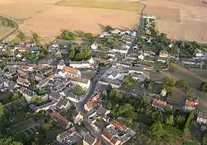 Blick auf Landes-le-Gaulois | ||

Geografie
Landes-le-Gaulois liegt etwa elf Kilometer nordwestlich von Blois am Cisse Landaise. Umgeben wird Landes-le-Gaulois von den Nachbargemeinden Tourailles und Villefrancœur im Norden, La Chapelle-Vendômoise im Nordosten, Saint-Bohaire im Osten und Südosten, Saint-Lubin-en-Vergonnois im Süden und Südosten, Herbault im Süden, Françay im Südwesten, Lancôme im Westen sowie Pray im Nordwesten.
Bevölkerungsentwicklung
| Jahr | 1962 | 1968 | 1975 | 1982 | 1990 | 1999 | 2006 | 2017 |
| Einwohner | 654 | 596 | 586 | 568 | 589 | 582 | 648 | 750 |
| Quellen: Cassini und INSEE | ||||||||
Sehenswürdigkeiten
- zahlreiche Dolmen
- Kirche Saint-Lubin, seit 1993 Monument historique
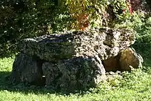
Dolmen Pierre Levée de la Garenne
This article is issued from Wikipedia. The text is licensed under Creative Commons - Attribution - Sharealike. The authors of the article are listed here. Additional terms may apply for the media files, click on images to show image meta data.