Torrejón de Velasco
Torrejón de Velasco ist eine spanische Gemeinde (municipio) in der Provinz Madrid in der Autonomen Gemeinschaft Madrid. Die Gemeinde zählte auf einer Fläche von 52,32 km² im Jahr 2016 4.243 Einwohner.
| Gemeinde Torrejón de Velasco | |||
|---|---|---|---|
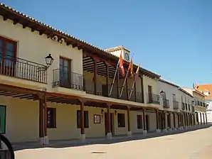 Das Rathaus (ayuntamiento) | |||
| Wappen | Karte von Spanien | ||
 |
| ||
| Basisdaten | |||
| Autonome Gemeinschaft: | Madrid | ||
| Provinz: | Madrid | ||
| Comarca: | La Sagra | ||
| Koordinaten | 40° 11′ N, 3° 47′ W | ||
| Höhe: | 605 msnm | ||
| Fläche: | 52,32 km² | ||
| Einwohner: | 4.382 (1. Jan. 2019)[1] | ||
| Bevölkerungsdichte: | 83,75 Einw./km² | ||
| Postleitzahl: | 28990 | ||
| Gemeindenummer (INE): | 28150 | ||
| Verwaltung | |||
| Bürgermeister: | Esteban Bravo Fernández | ||
| Website: | www8.madrid.org/gema/goc/150/ | ||
| Lage der Gemeinde | |||
_mapa.svg.png.webp) | |||

Lage
Die Gemeinde liegt rund 29 km südsüdwestlich von Madrid östlich der Autovía A-42, von der sie über die Straße M-404 erreicht wird.
Sehenswürdigkeiten
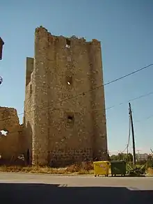
- Die Burg (castillo) mit mächtigem Turm.
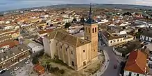
- Die Pfarrkirche.
- Fuente de la Teja.
- Fossilienfundstätte am Cerro de los Batallones.
Weblinks
Einzelnachweise
- Cifras oficiales de población resultantes de la revisión del Padrón municipal a 1 de enero. Bevölkerungsstatistiken des Instituto Nacional de Estadística (Bevölkerungsfortschreibung).
La Acebeda | Ajalvir | Alameda del Valle | El Álamo | Alcalá de Henares | Alcobendas | Alcorcón | Aldea del Fresno | Algete | Alpedrete | Ambite | Anchuelo | Aranjuez | Arganda del Rey | Arroyomolinos | El Atazar | Batres | Becerril de la Sierra | Belmonte de Tajo | El Berrueco | Berzosa del Lozoya | Boadilla del Monte | El Boalo | Braojos | Brea de Tajo | Brunete | Buitrago del Lozoya | Bustarviejo | Cabanillas de la Sierra | La Cabrera | Cadalso de los Vidrios | Camarma de Esteruelas | Campo Real | Canencia | Carabaña | Casarrubuelos | Cenicientos | Cercedilla | Cervera de Buitrago | Chapinería | Chinchón | Ciempozuelos | Cobeña | Colmenar de Oreja | Colmenar del Arroyo | Colmenar Viejo | Colmenarejo | Collado Mediano | Collado Villalba | Corpa | Coslada | Cubas de la Sagra | Daganzo de Arriba | El Escorial | Estremera | Fresnedillas de la Oliva | Fresno de Torote | Fuenlabrada | Fuente el Saz de Jarama | Fuentidueña de Tajo | Galapagar | Garganta de los Montes | Gargantilla del Lozoya y Pinilla de Buitrago | Gascones | Getafe | Griñón | Guadalix de la Sierra | Guadarrama | La Hiruela | Horcajo de la Sierra | Horcajuelo de la Sierra | Hoyo de Manzanares | Humanes de Madrid | Leganés | Loeches | Lozoya | Lozoyuela-Navas-Sieteiglesias | Madarcos | Madrid | Majadahonda | Manzanares el Real | Meco | Mejorada del Campo | Miraflores de la Sierra | El Molar | Los Molinos | Montejo de la Sierra | Moraleja de Enmedio | Moralzarzal | Morata de Tajuña | Móstoles | Navacerrada | Navalafuente | Navalagamella | Navalcarnero | Navarredonda y San Mamés | Navas del Rey | Nuevo Baztán | Olmeda de las Fuentes | Orusco de Tajuña | Paracuellos de Jarama | Parla | Patones | Pedrezuela | Pelayos de la Presa | Perales de Tajuña | Pezuela de las Torres | Pinilla del Valle | Pinto | Piñuécar-Gandullas | Pozuelo de Alarcón | Pozuelo del Rey | Prádena del Rincón | Puebla de la Sierra | Puentes Viejas | Quijorna | Rascafría | Redueña | Ribatejada | Rivas-Vaciamadrid | Robledillo de la Jara | Robledo de Chavela | Robregordo | Las Rozas de Madrid | Rozas de Puerto Real | San Agustín del Guadalix | San Fernando de Henares | San Lorenzo de El Escorial | San Martín de la Vega | San Martín de Valdeiglesias | San Sebastián de los Reyes | Santa María de la Alameda | Santorcaz | Los Santos de la Humosa | La Serna del Monte | Serranillos del Valle | Sevilla la Nueva | Somosierra | Soto del Real | Talamanca de Jarama | Tielmes | Titulcia | Torrejón de Ardoz | Torrejón de la Calzada | Torrejón de Velasco | Torrelaguna | Torrelodones | Torremocha de Jarama | Torres de la Alameda | Tres Cantos | Valdaracete | Valdeavero | Valdelaguna | Valdemanco | Valdemaqueda | Valdemorillo | Valdemoro | Valdeolmos-Alalpardo | Valdepiélagos | Valdetorres de Jarama | Valdilecha | Valverde de Alcalá | Velilla de San Antonio | El Vellón | Venturada | Villa del Prado | Villaconejos | Villalbilla | Villamanrique de Tajo | Villamanta | Villamantilla | Villanueva de la Cañada | Villanueva de Perales | Villanueva del Pardillo | Villar del Olmo | Villarejo de Salvanés | Villaviciosa de Odón | Villavieja del Lozoya | Zarzalejo