Sazeray
Sazeray ist eine französische Gemeinde mit 300 Einwohnern (Stand: 1. Januar 2019) im Département Indre in der Region Centre-Val de Loire. Sie gehört zum Arrondissement La Châtre, zum Kanton La Châtre (bis 2015: Kanton Sainte-Sévère-sur-Indre) und zum Gemeindeverband Communauté de communes de la Châtre et Sainte Sévère. Die Einwohner werden Sazerayens genannt.
| Sazeray | ||
|---|---|---|
| ||
| Staat | Frankreich | |
| Region | Centre-Val de Loire | |
| Département (Nr.) | Indre (36) | |
| Arrondissement | La Châtre | |
| Kanton | La Châtre | |
| Gemeindeverband | Châtre et Sainte Sévère | |
| Koordinaten | 46° 26′ N, 2° 3′ O | |
| Höhe | 260–432 m | |
| Fläche | 22,95 km² | |
| Einwohner | 300 (1. Januar 2019) | |
| Bevölkerungsdichte | 13 Einw./km² | |
| Postleitzahl | 36160 | |
| INSEE-Code | 36214 | |
_-_Mairie.jpg.webp) Rathaus (Mairie) von Sazeray | ||

Lage
Sazeray liegt etwa 44 Kilometer südsüdöstlich von Châteauroux. Umgeben wird Sazeray von den Nachbargemeinden Sainte-Sévère-sur-Indre im Norden, Vigoulant im Osten, Tercillat im Süden und Südosten, La Cellette im Süden, Nouziers im Südwesten sowie Pouligny-Notre-Dame im Westen und Nordwesten.
Bevölkerungsentwicklung
| Jahr | 1962 | 1968 | 1975 | 1982 | 1990 | 1999 | 2006 | 2013 |
| Einwohner | 684 | 607 | 524 | 447 | 370 | 319 | 325 | 314 |
| Quelle: Cassini und INSEE | ||||||||
Sehenswürdigkeiten
- Kirche Saint-Martin
- Schloss Le Mont aus dem 15. Jahrhundert
- Schloss Lavaubonneuil aus dem 15. Jahrhundert
- Reste des Schlosses Lavaupilière aus dem 15. Jahrhundert
_-_%C3%89glise_Saint-Martin_-_vue_de_cot%C3%A9.jpg.webp) Kirche Saint-Martin
Kirche Saint-Martin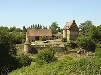 Schloss Le Mont
Weblinks
Commons: Sazeray – Sammlung von Bildern, Videos und Audiodateien
This article is issued from Wikipedia. The text is licensed under Creative Commons - Attribution - Sharealike. The authors of the article are listed here. Additional terms may apply for the media files, click on images to show image meta data.