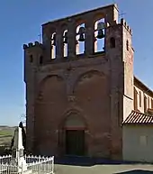
Sajas
Sajas (okzitanisch gleichlautend) ist eine französische Gemeinde mit 122 Einwohnern (Stand: 1. Januar 2019) im Département Haute-Garonne in der Region Okzitanien (zuvor Midi-Pyrénées). Sajas gehört zum Arrondissement Muret und zum Kanton Cazères. Die Einwohner werden Sajasains genannt.
| Sajas | ||
|---|---|---|
| ||
| Staat | Frankreich | |
| Region | Okzitanien | |
| Département (Nr.) | Haute-Garonne (31) | |
| Arrondissement | Muret | |
| Kanton | Cazères | |
| Gemeindeverband | Cœur de Garonne | |
| Koordinaten | 43° 23′ N, 1° 1′ O | |
| Höhe | 248–345 m | |
| Fläche | 5,02 km² | |
| Einwohner | 122 (1. Januar 2019) | |
| Bevölkerungsdichte | 24 Einw./km² | |
| Postleitzahl | 31370 | |
| INSEE-Code | 31520 | |

Geografie
Sajas liegt etwa 48 Kilometer südwestlich von Toulouse. Sajas wird umgeben von den Nachbargemeinden Le Pin-Murelet im Norden, Lautignac im Osten und Südosten, Montastruc-Savès im Süden und Westen sowie Montpézat im Westen und Nordwesten.
Bevölkerungsentwicklung
| Jahr | 1962 | 1968 | 1975 | 1982 | 1990 | 1999 | 2006 | 2013 |
| Einwohner | 103 | 96 | 65 | 62 | 71 | 82 | 90 | 113 |
| Quelle: Cassini und INSEE | ||||||||
Literatur
- Le Patrimoine des Communes de la Haute-Garonne. Flohic Editions, Band 2, Paris 2000, ISBN 2-84234-081-7, S. 1262–1264.
Weblinks
Commons: Sajas – Sammlung von Bildern, Videos und Audiodateien
This article is issued from Wikipedia. The text is licensed under Creative Commons - Attribution - Sharealike. The authors of the article are listed here. Additional terms may apply for the media files, click on images to show image meta data.