Latrape
Latrape (okzitanisch: La Trapa) ist eine französische Gemeinde mit 372 Einwohnern (Stand: 1. Januar 2019) im Département Haute-Garonne in der Region Okzitanien (vor 2016 Midi-Pyrénées). Latrape gehört zum Arrondissement Muret und zum Kanton Auterive (bis 2015 Rieux-Volvestre). Die Einwohner werden Trapéens oder Trappistes genannt.
| Latrape La Trapa | ||
|---|---|---|
| ||
| Staat | Frankreich | |
| Region | Okzitanien | |
| Département (Nr.) | Haute-Garonne (31) | |
| Arrondissement | Muret | |
| Kanton | Auterive | |
| Gemeindeverband | Volvestre | |
| Koordinaten | 43° 15′ N, 1° 17′ O | |
| Höhe | 227–369 m | |
| Fläche | 19,47 km² | |
| Einwohner | 372 (1. Januar 2019) | |
| Bevölkerungsdichte | 19 Einw./km² | |
| Postleitzahl | 31310 | |
| INSEE-Code | 31280 | |
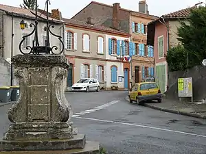 Rathaus (Mairie) von Latrape | ||

Geographie
Latrape liegt etwa 27 Kilometer südsüdwestlich von Muret. Umgeben wird Latrape von den Nachbargemeinden Lacaugne im Norden, Lézat-sur-Lèze im Nordosten, Castagnac im Osten, Canens im Südosten, Bax im Süden, Mailholas und Rieux-Volvestre im Westen sowie Carbonne im Nordwesten.
Bevölkerungsentwicklung
| Jahr | 1962 | 1968 | 1975 | 1982 | 1990 | 1999 | 2006 | 2013 |
| Einwohner | 359 | 296 | 222 | 213 | 212 | 297 | 337 | 340 |
| Quelle: Cassini und INSEE | ||||||||
Sehenswürdigkeiten
- Kirche Saint-Barthélemy
- Volkssternwarte Les Pleiades
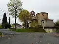 Kirche Saint-Barthélemy
 Volkssternwarte
Literatur
- Le Patrimoine des Communes de la Haute-Garonne. Flohic Editions, Band 2, Paris 2000, ISBN 2-84234-081-7, S. 1274–1275.
Weblinks
Commons: Latrape – Sammlung von Bildern, Videos und Audiodateien
This article is issued from Wikipedia. The text is licensed under Creative Commons - Attribution - Sharealike. The authors of the article are listed here. Additional terms may apply for the media files, click on images to show image meta data.