Saint-Remy (Vosges)
| Saint-Remy | ||
|---|---|---|
|
| |
| Staat | Frankreich | |
| Region | Grand Est | |
| Département (Nr.) | Vosges (88) | |
| Arrondissement | Saint-Dié-des-Vosges | |
| Kanton | Raon-l’Étape | |
| Gemeindeverband | Saint-Dié-des-Vosges | |
| Koordinaten | 48° 21′ N, 6° 50′ O | |
| Höhe | 317–524 m | |
| Fläche | 12,27 km² | |
| Einwohner | 518 (1. Januar 2019) | |
| Bevölkerungsdichte | 42 Einw./km² | |
| Postleitzahl | 88484 | |
| INSEE-Code | 88435 | |

Saint-Remy ist eine auf 350 Metern über Meereshöhe gelegene französische Gemeinde im Département Vosges in der Region Grand Est (bis 2015 Lothringen). Sie gehört zum Kanton Raon-l’Étape im Arrondissement Saint-Dié-des-Vosges. Sie grenzt im Nordwesten, im Norden und im Nordosten an Étival-Clairefontaine, im Südosten an Nompatelize, im Süden an La Salle, im Südwesten an Jeanménil und im Westen an Saint-Benoît-la-Chipotte.
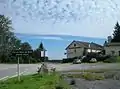 Pass Col du Haut de Bois
 Pass Col de la Chipotte
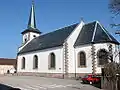 Kirche Saint-Remy
Bevölkerungsentwicklung
| Jahr | 1962 | 1968 | 1975 | 1982 | 1990 | 1999 | 2008 | 2014 |
|---|---|---|---|---|---|---|---|---|
| Einwohner | 317 | 295 | 342 | 360 | 418 | 428 | 505 | 518 |
Weblinks
Commons: Saint-Remy – Sammlung von Bildern, Videos und Audiodateien
This article is issued from Wikipedia. The text is licensed under Creative Commons - Attribution - Sharealike. The authors of the article are listed here. Additional terms may apply for the media files, click on images to show image meta data.