Les Rouges-Eaux
Les Rouges-Eaux ist eine französische Gemeinde mit 85 Einwohnern (Stand: 1. Januar 2019) in der Region Grand Est (bis 2015 Lothringen). Sie gehört zum Arrondissement Saint-Dié-des-Vosges, zum Département Vosges und zum Kanton Bruyères. Der Fluss Mortagne fließt durch die Gemeinde. Das Gemeindegebiet umfasst eine Fläche von 5,9 km². Les Rouges-Eaux grenzt an Bois-de-Champ, Domfaing, Mortagne und Taintrux.
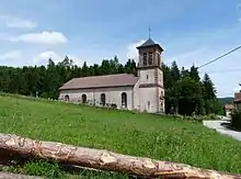
Kirche Saint-Jean-Baptiste
| Les Rouges-Eaux | ||
|---|---|---|
| ||
| Staat | Frankreich | |
| Region | Grand Est | |
| Département (Nr.) | Vosges (88) | |
| Arrondissement | Saint-Dié-des-Vosges | |
| Kanton | Bruyères | |
| Gemeindeverband | Saint-Dié-des-Vosges | |
| Koordinaten | 48° 16′ N, 6° 48′ O | |
| Höhe | 377–620 m | |
| Fläche | 6,00 km² | |
| Einwohner | 85 (1. Januar 2019) | |
| Bevölkerungsdichte | 14 Einw./km² | |
| Postleitzahl | 88600 | |
| INSEE-Code | 88398 | |
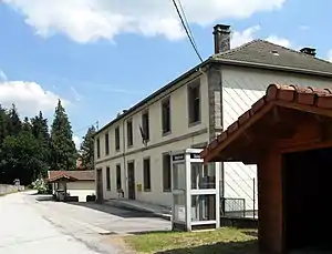 Mairie Les Rouges-Eaux | ||

Weblinks
Commons: Les Rouges-Eaux – Sammlung von Bildern, Videos und Audiodateien
This article is issued from Wikipedia. The text is licensed under Creative Commons - Attribution - Sharealike. The authors of the article are listed here. Additional terms may apply for the media files, click on images to show image meta data.