Saint-Prouant
| Saint-Prouant | ||
|---|---|---|
.svg.png.webp)
|
| |
| Staat | Frankreich | |
| Region | Pays de la Loire | |
| Département (Nr.) | Vendée (85) | |
| Arrondissement | La Roche-sur-Yon | |
| Kanton | Chantonnay | |
| Gemeindeverband | Pays de Chantonnay | |
| Koordinaten | 46° 46′ N, 0° 57′ W | |
| Höhe | 54–118 m | |
| Fläche | 12,95 km² | |
| Einwohner | 1.662 (1. Januar 2019) | |
| Bevölkerungsdichte | 128 Einw./km² | |
| Postleitzahl | 85110 | |
| INSEE-Code | 85266 | |
| Website | http://www.saintprouant.fr/ | |

Saint-Prouant ist eine französische Gemeinde mit 1.662 Einwohnern (Stand: 1. Januar 2019) im Département Vendée in der Region Pays de la Loire. Sie gehört zum Arrondissement La Roche-sur-Yon und ist Teil des Kantons Chantonnay. Die Einwohner heißen Prouantais.
Geografie
Saint-Prouant liegt etwa 37 Kilometer ostnordöstlich von La Roche-sur-Yon. Die Gemeinde wird im Osten vom Fluss Lay begrenzt. Umgeben wird Saint-Prouant von den Nachbargemeinden Le Boupère im Norden, Monsireigne im Osten und Südosten, Sigournais im Süden, Saint-Germain-de-Prinçay im Südwesten, Mouchamps im Westen sowie Rochetrejoux im Nordwesten.
Bevölkerungsentwicklung
| Jahr | 1962 | 1968 | 1975 | 1982 | 1990 | 1999 | 2006 | 2013 |
| Einwohner | 767 | 779 | 899 | 1.076 | 1.240 | 1.305 | 1.402 | 1.504 |
| Quelle: Cassini und INSEE | ||||||||
Sehenswürdigkeiten
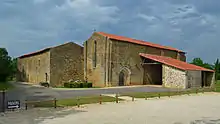
Grammontenserpriorat
- Grammontenserpriorat, Monument historique seit 1987
- Protestantische Kirche
Persönlichkeiten
- Achille Daroux (1880–1953), Politiker
Literatur
- Le Patrimoine des Communes de la Vendée. Flohic Editions, Band 1, Paris 2001, ISBN 2-84234-118-X, S. 147–149.
This article is issued from Wikipedia. The text is licensed under Creative Commons - Attribution - Sharealike. The authors of the article are listed here. Additional terms may apply for the media files, click on images to show image meta data.