Saint-Maurice-la-Clouère
Saint-Maurice-la-Clouère ist eine französische Gemeinde mit 1.299 Einwohnern (Stand: 1. Januar 2019) im Département Vienne in der Region Nouvelle-Aquitaine (vor 2016: Poitou-Charentes). Sie gehört zum Arrondissement Montmorillon und zum Kanton Lussac-les-Châteaux (bis 2015: Kanton Gençay).
| Saint-Maurice-la-Clouère | ||
|---|---|---|
| ||
| Staat | Frankreich | |
| Region | Nouvelle-Aquitaine | |
| Département (Nr.) | Vienne (86) | |
| Arrondissement | Montmorillon | |
| Kanton | Lussac-les-Châteaux | |
| Gemeindeverband | Civraisien en Poitou | |
| Koordinaten | 46° 23′ N, 0° 25′ O | |
| Höhe | 105–139 m | |
| Fläche | 40,19 km² | |
| Einwohner | 1.299 (1. Januar 2019) | |
| Bevölkerungsdichte | 32 Einw./km² | |
| Postleitzahl | 86160 | |
| INSEE-Code | 86235 | |
| Website | www.saintmauricelaclouere.fr | |

Geographie
Saint-Maurice-la-Clouère liegt etwa 23 Kilometer südsüdöstlich von Poitiers am Clouère. Umgeben wird Saint-Maurice-la-Clouère von den Nachbargemeinden Gizay im Norden, Vernon im Norden und Nordosten, Saint-Laurent-de-Jourdes im Osten, Brion im Süden und Südosten, Gençay im Süden sowie Marnay im Westen.
Durch die Gemeinde führt die Via Turonensis, eine Variante des Jakobswegs.
Bevölkerungsentwicklung
| Jahr | 1962 | 1968 | 1975 | 1982 | 1990 | 1999 | 2006 | 2013 |
| Einwohner | 907 | 910 | 852 | 825 | 952 | 1.058 | 1.110 | 1.275 |
| Quelle: Cassini und INSEE | ||||||||
Sehenswürdigkeiten
Siehe auch: Liste der Monuments historiques in Saint-Maurice-la-Clouère
- Kirche Saint-Maurice, Monument historique
- Schloss L’Audonnière
- Schloss Galmoisin, seit 1989 Monument historique
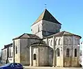 Kirche Saint-Maurice
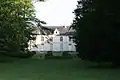 Schloss L’Audonnière
Literatur
- Le Patrimoine des Communes de la Vienne. Band 1, Flohic Editions, Paris 2002, ISBN 2-84234-128-7, S. 324–332.
Weblinks
Commons: Saint-Maurice-la-Clouère – Sammlung von Bildern, Videos und Audiodateien
This article is issued from Wikipedia. The text is licensed under Creative Commons - Attribution - Sharealike. The authors of the article are listed here. Additional terms may apply for the media files, click on images to show image meta data.