Saint-Agoulin
| Saint-Agoulin | ||
|---|---|---|
.svg.png.webp)
|
| |
| Staat | Frankreich | |
| Region | Auvergne-Rhône-Alpes | |
| Département (Nr.) | Puy-de-Dôme (63) | |
| Arrondissement | Riom | |
| Kanton | Aigueperse | |
| Gemeindeverband | Plaine Limagne | |
| Koordinaten | 46° 3′ N, 3° 8′ O | |
| Höhe | 397–578 m | |
| Fläche | 9,36 km² | |
| Einwohner | 339 (1. Januar 2019) | |
| Bevölkerungsdichte | 36 Einw./km² | |
| Postleitzahl | 63260 | |
| INSEE-Code | 63311 | |
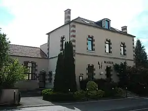 Rathaus (Mairie) von Saint-Agoulin | ||

Saint-Agoulin ist eine französische Gemeinde mit 339 Einwohnern (Stand: 1. Januar 2019) im Département Puy-de-Dôme in der Region Auvergne-Rhône-Alpes. Die Gemeinde gehört zum Arrondissement Riom und zum Kanton Aigueperse.
Lage
Saint-Agoulin liegt etwa 15 Kilometer nordnordöstlich von Riom. Umgeben wird Saint-Agoulin von den Nachbargemeinden Vensat im Norden und Nordosten, Chaptuzat im Osten, Artonne im Süden, Jozerand im Westen und Südwesten sowie Champs im Westen und Nordwesten.
Bevölkerungsentwicklung
| Jahr | 1962 | 1968 | 1975 | 1982 | 1990 | 1999 | 2008 | 2018 |
| Einwohner | 270 | 280 | 267 | 234 | 212 | 246 | 272 | 334 |
| Quellen: Cassini und INSEE | ||||||||
Sehenswürdigkeiten
- Kirche Saint-Jean-Baptiste
- Schloss Saint-Agoulin
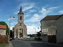
Kirche Saint-Jean-Baptiste
Weblinks
Commons: Saint-Agoulin – Sammlung von Bildern, Videos und Audiodateien
This article is issued from Wikipedia. The text is licensed under Creative Commons - Attribution - Sharealike. The authors of the article are listed here. Additional terms may apply for the media files, click on images to show image meta data.