Chappes (Puy-de-Dôme)
Chappes ist eine Gemeinde mit 1.630 Einwohnern (Stand: 1. Januar 2019) im zentralfranzösischen Département Puy-de-Dôme in der Region Auvergne-Rhône-Alpes. Die Gemeinde gehört zum Arrondissement Riom und zum Kanton Aigueperse (bis 2015: Kanton Ennezat). Die Einwohner werden Chappadaires genannt.
| Chappes | ||
|---|---|---|
.svg.png.webp)
|
| |
| Staat | Frankreich | |
| Region | Auvergne-Rhône-Alpes | |
| Département (Nr.) | Puy-de-Dôme (63) | |
| Arrondissement | Riom | |
| Kanton | Aigueperse | |
| Gemeindeverband | Riom Limagne et Volcans | |
| Koordinaten | 45° 52′ N, 3° 13′ O | |
| Höhe | 307–333 m | |
| Fläche | 10,45 km² | |
| Einwohner | 1.630 (1. Januar 2019) | |
| Bevölkerungsdichte | 156 Einw./km² | |
| Postleitzahl | 63720 | |
| INSEE-Code | 63089 | |
| Website | http://www.mairiechappes63.com/ | |
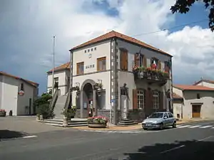 Rathaus (Mairie) von Chappes | ||

Lage
Chappes liegt etwa 14 Kilometer nordöstlich von Clermont-Ferrand am Bédat. Umgeben wird Chappes von den Nachbargemeinden Ennezat im Norden, Entraigues im Osten und Nordosten, Chavaroux im Osten und Südosten, Lussat im Süden sowie Saint-Beauzire im Westen.
Bevölkerungsentwicklung
| Jahr | 1962 | 1968 | 1975 | 1982 | 1990 | 1999 | 2006 | 2013 |
| Einwohner | 551 | 545 | 718 | 802 | 987 | 1.158 | 1.430 | 1.595 |
| Quellen: Cassini und INSEE | ||||||||
Sehenswürdigkeiten
- Kirche Saint-François
Weblinks
Commons: Chappes – Sammlung von Bildern, Videos und Audiodateien
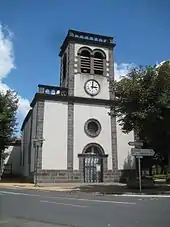
Kirche Saint-François in Chappes
This article is issued from Wikipedia. The text is licensed under Creative Commons - Attribution - Sharealike. The authors of the article are listed here. Additional terms may apply for the media files, click on images to show image meta data.