Sévigny-Waleppe
Sévigny-Waleppe ist eine französische Gemeinde mit 224 Einwohnern (Stand 1. Januar 2019) im Département Ardennes in der Region Grand Est; sie gehört zum Arrondissement Rethel und zum Kanton Château-Porcien.
| Sévigny-Waleppe | ||
|---|---|---|
| ||
| Staat | Frankreich | |
| Region | Grand Est | |
| Département (Nr.) | Ardennes (08) | |
| Arrondissement | Rethel | |
| Kanton | Château-Porcien | |
| Gemeindeverband | Pays Rethélois | |
| Koordinaten | 49° 36′ N, 4° 5′ O | |
| Höhe | 93–163 m | |
| Fläche | 24,28 km² | |
| Einwohner | 224 (1. Januar 2019) | |
| Bevölkerungsdichte | 9 Einw./km² | |
| Postleitzahl | 08220 | |
| INSEE-Code | 08418 | |
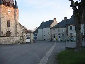 Der Ortskern von Sevigny-Waleppe | ||

Geographie
Sévigny-Waleppe besteht aus den Ortsteilen Sévigny und Waleppe, das 2,3 Kilometer nordöstlich von Sévigny liegt. Sévigny wurde früher auch Sévigny-en-Thiérache genannt. Das Gemeindegebiet wird vom Fluss Barres durchquert.
Bevölkerungsentwicklung
| Jahr | 1962 | 1968 | 1975 | 1982 | 1990 | 1999 | 2007 | 2016 |
| Einwohner | 309 | 373 | 334 | 303 | 269 | 257 | 253 | 228 |
Sehenswürdigkeiten
- Kirche Saint-Leu (13. Jahrhundert, Monument historique)
- Burg (1391, 1573–1606 bzw. 1690)
This article is issued from Wikipedia. The text is licensed under Creative Commons - Attribution - Sharealike. The authors of the article are listed here. Additional terms may apply for the media files, click on images to show image meta data.