Hannogne-Saint-Rémy
Hannogne-Saint-Rémy ist eine französische Gemeinde mit 112 Einwohnern (Stand: 1. Januar 2019) im Département Ardennes in der Region Grand Est (bis 2015 Champagne-Ardenne). Sie gehört zum Arrondissement Rethel, zum Kanton Château-Porcien sowie zum Gemeindeverband Pays Rethélois.
| Hannogne-Saint-Rémy | ||
|---|---|---|
| ||
| Staat | Frankreich | |
| Region | Grand Est | |
| Département (Nr.) | Ardennes (08) | |
| Arrondissement | Rethel | |
| Kanton | Château-Porcien | |
| Gemeindeverband | Pays Rethélois | |
| Koordinaten | 49° 36′ N, 4° 8′ O | |
| Höhe | 91–167 m | |
| Fläche | 18,12 km² | |
| Einwohner | 112 (1. Januar 2019) | |
| Bevölkerungsdichte | 6 Einw./km² | |
| Postleitzahl | 08220 | |
| INSEE-Code | 08210 | |
 Rathaus (Mairie) von Hannogne-Saint-Rémy | ||

Geographie
Umgeben wird Hannogne-Saint-Rémy von den Nachbargemeinden Sévigny-Waleppe im Westen und Nordwesten, Seraincourt im Nordosten und Osten, Saint-Fergeux im Südosten, Banogne-Recouvrance im Süden sowie Saint-Quentin-le-Petit im Südwesten.
Bevölkerungsentwicklung
| Jahr | 1962 | 1968 | 1975 | 1982 | 1990 | 1999 | 2006 | 2012 | 2016 |
| Einwohner | 257 | 213 | 197 | 165 | 121 | 104 | 115 | 113 | 111 |
| Quelle: Cassini und INSEE | |||||||||
Sehenswürdigkeiten
- Kirche Saint-Pierre
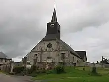
Kirche Saint-Pierre
This article is issued from Wikipedia. The text is licensed under Creative Commons - Attribution - Sharealike. The authors of the article are listed here. Additional terms may apply for the media files, click on images to show image meta data.