Aire (Ardennes)
Aire ist eine französische Gemeinde mit 236 Einwohnern (Stand: 1. Januar 2019) im Département Ardennes in der Region Grand Est (bis 2015 Champagne-Ardenne). Sie gehört zum Arrondissement Rethel und zum Kanton Château-Porcien.
| Aire | ||
|---|---|---|
| ||
| Staat | Frankreich | |
| Region | Grand Est | |
| Département (Nr.) | Ardennes (08) | |
| Arrondissement | Rethel | |
| Kanton | Château-Porcien | |
| Gemeindeverband | Pays Rethélois | |
| Koordinaten | 49° 29′ N, 4° 10′ O | |
| Höhe | 61–125 m | |
| Fläche | 6,81 km² | |
| Einwohner | 236 (1. Januar 2019) | |
| Bevölkerungsdichte | 35 Einw./km² | |
| Postleitzahl | 08190 | |
| INSEE-Code | 08004 | |
_Mairie.JPG.webp) Mairie Aire | ||

Nachbargemeinden sind Balham im Norden, Blanzy-la-Salonnaise und Saint-Loup-en-Champagne im Osten, Roizy im Süden sowie Asfeld im Westen.
Bevölkerungsentwicklung
| Jahr | 1962 | 1968 | 1975 | 1982 | 1990 | 1999 | 2008 | 2018 |
|---|---|---|---|---|---|---|---|---|
| Einwohner | 177 | 182 | 180 | 160 | 163 | 205 | 224 | 228 |
Sehenswürdigkeiten
- Kirche Saint-Remi
- Flurkreuz
- Kriegerdenkmal
_%C3%89glise.JPG.webp) Kirche Saint-Remi
Kirche Saint-Remi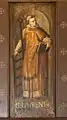 Wandgemälde in der Kirche
_Canal_des_Ardennes.JPG.webp) Der Canal des Ardennes bei Aire
Der Canal des Ardennes bei Aire
This article is issued from Wikipedia. The text is licensed under Creative Commons - Attribution - Sharealike. The authors of the article are listed here. Additional terms may apply for the media files, click on images to show image meta data.