Gomont
Gomont ist eine französische Gemeinde mit 326 Einwohnern (Stand 1. Januar 2019) im Département Ardennes in der Region Grand Est (vor 2016 Champagne-Ardenne). Sie gehört zum Arrondissement Rethel, zum Kanton Château-Porcien und zum Gemeindeverband Pays Rethélois.
| Gomont | ||
|---|---|---|

|
| |
| Staat | Frankreich | |
| Region | Grand Est | |
| Département (Nr.) | Ardennes (08) | |
| Arrondissement | Rethel | |
| Kanton | Château-Porcien | |
| Gemeindeverband | Pays Rethélois | |
| Koordinaten | 49° 30′ N, 4° 10′ O | |
| Höhe | 63–135 m | |
| Fläche | 7,14 km² | |
| Einwohner | 326 (1. Januar 2019) | |
| Bevölkerungsdichte | 46 Einw./km² | |
| Postleitzahl | 08190 | |
| INSEE-Code | 08195 | |
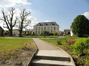 Rathaus (Mairie) von Gomont | ||

Geografie
Die Gemeinde Gomont liegt an der oberen Aisne, etwa 35 Kilometer nordnordöstlich von Reims. Umgeben wird Gomont von den Nachbargemeinden Saint-Germainmont im Westen, Herpy-l’Arlésienne im Nordosten, Blanzy-la-Salonnaise im Südosten sowie Balham im Südwesten.
Bevölkerungsentwicklung
| Jahr | 1962 | 1968 | 1975 | 1982 | 1990 | 1999 | 2006 | 2018 |
| Einwohner | 415 | 394 | 342 | 309 | 292 | 320 | 319 | 324 |
| Quellen: Cassini und INSEE | ||||||||
Sehenswürdigkeiten
_%C3%89glise_Saint-Quentin.JPG.webp)
Kirche Saint-Quentin
- Kirche Saint-Quentin
This article is issued from Wikipedia. The text is licensed under Creative Commons - Attribution - Sharealike. The authors of the article are listed here. Additional terms may apply for the media files, click on images to show image meta data.