Plourin
| Plourin | ||
|---|---|---|

|
| |
| Staat | Frankreich | |
| Region | Bretagne | |
| Département (Nr.) | Finistère (29) | |
| Arrondissement | Brest | |
| Kanton | Saint-Renan | |
| Gemeindeverband | Pays d’Iroise | |
| Koordinaten | 48° 31′ N, 4° 41′ W | |
| Höhe | 25–94 m | |
| Fläche | 25,65 km² | |
| Einwohner | 1.245 (1. Januar 2019) | |
| Bevölkerungsdichte | 49 Einw./km² | |
| Postleitzahl | 29830 | |
| INSEE-Code | 29208 | |
| Website | offizielle Website | |
Plourin (bret. Plourin-Gwitalmeze) ist eine französische Gemeinde mit 1245 Einwohnern (Stand 1. Januar 2019) im Département Finistère in der Region Bretagne; sie gehört zum Arrondissement Brest und zum Kanton Saint-Renan.
Bevölkerungsentwicklung
| Jahr | 1962 | 1968 | 1975 | 1982 | 1990 | 1999 | 2006 | 2017 |
| Einwohner | 1125 | 978 | 851 | 889 | 895 | 983 | 1208 | 1241 |
Geschichte
Die Gemeinde gehörte ursprünglich zum Gebiet Nieder-Leon (frz. Bas-Léon, bret. Goueled-Leon) im Nordwesten der Bretagne, später zur Herrschaft von Brest und Saint-Renan.
Sehenswürdigkeiten
Siehe auch: Liste der Monuments historiques in Plourin
- Rathaus, ein ehemaliges Armenhaus aus dem 17./18. Jahrhundert
- Kirche Saint-Budoc aus dem Jahr 1893, gebaut von Ernest Le Guerranic
- Kapelle Saint-Roch
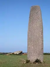
- Menhire von Kergadiou
- Kalvarienberg aus dem Jahr 1874
 Kirche Saint-Budoc
 Rathaus
.JPG.webp) Rückseite des Rathauses
Rückseite des Rathauses Menhir von Kergadiou
Literatur
- Le Patrimoine des Communes du Finistère. Flohic Editions, Band 2, Paris 1998, ISBN 2-84234-039-6, S. 975–978.
This article is issued from Wikipedia. The text is licensed under Creative Commons - Attribution - Sharealike. The authors of the article are listed here. Additional terms may apply for the media files, click on images to show image meta data.
