Northampton County (Pennsylvania)
Northampton County[1] ist ein County im Bundesstaat Pennsylvania der Vereinigten Staaten. Bei der Volkszählung im Jahr 2020 hatte das County 312.951 Einwohner und eine Bevölkerungsdichte von 323 Einwohner pro Quadratkilometer.[2] Der Verwaltungssitz (County Seat) ist Easton.
| Verwaltung | |
|---|---|
| US-Bundesstaat: | Pennsylvania |
| Verwaltungssitz: | Easton |
| Gründung: | 7. März 1752 |
| Gebildet aus: | Bucks County |
| Vorwahl: | 001 610 |
| Demographie | |
| Einwohner: | 312.951 (2020) |
| Bevölkerungsdichte: | 323,3 Einwohner/km2 |
| Geographie | |
| Fläche gesamt: | 977 km² |
| Wasserfläche: | 9 km² |
| Karte | |
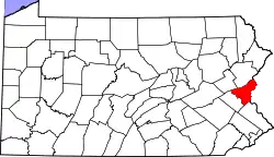 Karte von Northampton County innerhalb von Pennsylvania | |
| Website: www.northamptoncounty.org | |
Geschichte
Das County wurde am 11. März 1752 gebildet. Der Name geht auf das Anwesen von William Penn in Northamptonshire zurück und wurde von seinem Schwiegersohn vorgeschlagen.[3]
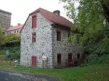
Vier Orte im County haben den Status einer National Historic Landmark.[4] 51 Bauwerke und Stätten des Countys sind im National Register of Historic Places (NRHP) eingetragen (Stand 24. Juli 2018).[5]
Geographie
Das County hat eine Fläche von 977 Quadratkilometern, wovon 9 Quadratkilometer Wasserfläche sind.
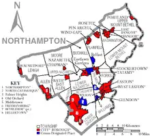
Städte und Ortschaften
|
|
|
| Bevölkerungsentwicklung | |||
|---|---|---|---|
| Census | Einwohner | ± in % | |
| 1900 | 99.687 | — | |
| 1910 | 127.667 | 28,1 % | |
| 1920 | 153.506 | 20,2 % | |
| 1930 | 169.304 | 10,3 % | |
| 1940 | 168.959 | −0,2 % | |
| 1950 | 185.243 | 9,6 % | |
| 1960 | 201.412 | 8,7 % | |
| 1970 | 214.368 | 6,4 % | |
| 1980 | 225.418 | 5,2 % | |
| 1990 | 247.105 | 9,6 % | |
| 2000 | 267.066 | 8,1 % | |
| 2010 | 297.735 | 11,5 % | |
| 2020 | 312.951 | 5,1 % | |
| 1900–1990[6]
2000[7] | |||
Weblinks
Einzelnachweise
- Northampton County im Geographic Names Information System des United States Geological Survey. Abgerufen am 22. Februar 2011
- U.S. Census Bureau QuickFacts: Northampton County, Pennsylvania. Abgerufen am 28. August 2021 (englisch).
- Charles Curry Aiken, Joseph Nathan Kane: The American Counties: Origins of County Names, Dates of Creation, Area, and Population Data, 1950–2010. 6. Auflage. Scarecrow Press, Lanham 2013, ISBN 978-0-8108-8762-6, S. 225.
- Listing of National Historic Landmarks by State: Pennsylvania. National Park Service, abgerufen am 23. Juli 2018.
- Suchmaske Datenbank im National Register Information System. National Park Service, abgerufen am 24. Juli 2018.
- Auszug aus Census.gov. Abgerufen am 28. Februar 2011
- Auszug aus factfinder.census.gov Abgerufen am 28. Februar 2011
Liste der Countys in Pennsylvania
Adams |
Allegheny |
Armstrong |
Beaver |
Bedford |
Berks |
Blair |
Bradford |
Bucks |
Butler |
Cambria |
Cameron |
Carbon |
Centre |
Chester |
Clarion |
Clearfield |
Clinton |
Columbia |
Crawford |
Cumberland |
Dauphin |
Delaware |
Elk |
Erie |
Fayette |
Forest |
Franklin |
Fulton |
Greene |
Huntingdon |
Indiana |
Jefferson |
Juniata |
Lackawanna |
Lancaster |
Lawrence |
Lebanon |
Lehigh |
Luzerne |
Lycoming |
McKean |
Mercer |
Mifflin |
Monroe |
Montgomery |
Montour |
Northampton |
Northumberland |
Perry |
Philadelphia |
Pike |
Potter |
Schuylkill |
Snyder |
Somerset |
Sullivan |
Susquehanna |
Tioga |
Union |
Venango |
Warren |
Washington |
Wayne |
Westmoreland |
Wyoming |
York