Columbia County (Pennsylvania)
Columbia County[1] ist ein County im Bundesstaat Pennsylvania der Vereinigten Staaten. Im Jahr 2020 hatte das County 64.727 Einwohner und eine Bevölkerungsdichte von 51,5 Einwohner pro Quadratkilometer.[2] Der Verwaltungssitz (County Seat) ist Bloomsburg.
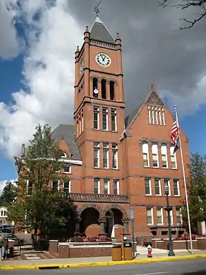 Columbia County Courthouse | |
| Verwaltung | |
|---|---|
| US-Bundesstaat: | Pennsylvania |
| Verwaltungssitz: | Bloomsburg |
| Adresse des Verwaltungssitzes: |
Courthouse 35 West Main Street PO Box 380 Bloomsburg, PA 17815-0380 |
| Gründung: | 22. März 1813 |
| Gebildet aus: | Northumberland County Luzerne County |
| Vorwahl: | 001 570 |
| Demographie | |
| Einwohner: | 64.727 (2020) |
| Bevölkerungsdichte: | 51,45 Einwohner/km2 |
| Geographie | |
| Fläche gesamt: | 1269 km² |
| Wasserfläche: | 11 km² |
| Karte | |
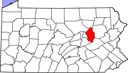 Karte von Columbia County innerhalb von Pennsylvania | |
| Website: www.columbiapa.org | |
Geschichte
Das County wurde am 22. März 1813 aus Teilen des Northumberland Countys gebildet und nach Christoph Kolumbus benannt.[3]
28 Bauwerke und Stätten des Countys sind im National Register of Historic Places (NRHP) eingetragen (Stand 22. Juli 2018).[4]
Geographie
Das County hat eine Fläche von 1269 Quadratkilometern, wovon 11 Quadratkilometer (0,87 Prozent) Wasserflächen sind. Die benachbarten Countys sind:
- Sullivan County (nördlich)
- Luzerne County (östlich)
- Schuylkill County (südlich)
- Northumberland County (südwestlich)
- Montour County (westlich)
- Lycoming County (nordwestlich)
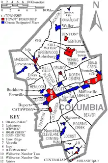
Städte und Ortschaften
|
|
|
| Bevölkerungsentwicklung | |||
|---|---|---|---|
| Census | Einwohner | ± in % | |
| 1900 | 39.896 | — | |
| 1910 | 48.467 | 21,5 % | |
| 1920 | 48.349 | −0,2 % | |
| 1930 | 48.803 | 0,9 % | |
| 1940 | 51.413 | 5,3 % | |
| 1950 | 53.460 | 4 % | |
| 1960 | 53.489 | 0,1 % | |
| 1970 | 55.114 | 3 % | |
| 1980 | 61.967 | 12,4 % | |
| 1990 | 63.202 | 2 % | |
| 2000 | 64.148 | 1,5 % | |
| 2010 | 67.295 | 4,9 % | |
| 2020 | 64.727 | −3,8 % | |
| 1900–1990[5]
2000[6] | |||
Einzelnachweise
- Columbia County (Englisch) In: Geographic Names Information System. United States Geological Survey. Abgerufen am 22. Februar 2011.
- U.S. Census Bureau QuickFacts: Columbia County, Pennsylvania. Abgerufen am 28. August 2021 (englisch).
- Charles Curry Aiken, Joseph Nathan Kane: The American Counties: Origins of County Names, Dates of Creation, Area, and Population Data, 1950–2010. 6. Auflage. Scarecrow Press, Lanham 2013, ISBN 978-0-8108-8762-6, S. 67.
- Suchmaske Datenbank im National Register Information System. National Park Service, abgerufen am 22. Juli 2018.
- Auszug aus Census.gov. Abgerufen am 28. Februar 2011
- Auszug aus factfinder.census.gov Abgerufen am 28. Februar 2011
Weblinks
Liste der Countys in Pennsylvania
Adams |
Allegheny |
Armstrong |
Beaver |
Bedford |
Berks |
Blair |
Bradford |
Bucks |
Butler |
Cambria |
Cameron |
Carbon |
Centre |
Chester |
Clarion |
Clearfield |
Clinton |
Columbia |
Crawford |
Cumberland |
Dauphin |
Delaware |
Elk |
Erie |
Fayette |
Forest |
Franklin |
Fulton |
Greene |
Huntingdon |
Indiana |
Jefferson |
Juniata |
Lackawanna |
Lancaster |
Lawrence |
Lebanon |
Lehigh |
Luzerne |
Lycoming |
McKean |
Mercer |
Mifflin |
Monroe |
Montgomery |
Montour |
Northampton |
Northumberland |
Perry |
Philadelphia |
Pike |
Potter |
Schuylkill |
Snyder |
Somerset |
Sullivan |
Susquehanna |
Tioga |
Union |
Venango |
Warren |
Washington |
Wayne |
Westmoreland |
Wyoming |
York