Forest County (Pennsylvania)
Forest County[1] ist ein County im Bundesstaat Pennsylvania der Vereinigten Staaten. Bei der Volkszählung im Jahr 2020 hatte das County 6973 Einwohner und eine Bevölkerungsdichte von 6 Einwohner pro Quadratkilometer.[2] Der Verwaltungssitz (County Seat) ist Tionesta.
 Forest County Courthouse | |
| Verwaltung | |
|---|---|
| US-Bundesstaat: | Pennsylvania |
| Verwaltungssitz: | Tionesta |
| Adresse des Verwaltungssitzes: |
526 Elm Street, Box 3 Tionesta, PA 16353 |
| Gründung: | 11. April 1848 |
| Gebildet aus: | Jefferson County |
| Vorwahl: | 001 814 |
| Demographie | |
| Einwohner: | 6973 (2020) |
| Bevölkerungsdichte: | 6,29 Einwohner/km2 |
| Geographie | |
| Fläche gesamt: | 1117 km² |
| Wasserfläche: | 8 km² |
| Karte | |
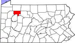 Karte von Forest County innerhalb von Pennsylvania | |
| Website: www.co.forest.pa.us | |
Geschichte
Das Forest County wurde am 11. April 1848 gebildet. Der Name bezieht sich auf die starke Bewaldung der Region.[3]
Vier Bauwerke und Stätten des Countys sind im National Register of Historic Places (NRHP) eingetragen (Stand 23. Juli 2018).[4]
Geographie
Das County hat eine Fläche von 1117 Quadratkilometern, wovon 8 Quadratkilometer Wasserfläche sind.
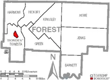
Orte im Forest County
Das Forest County ist unterteilt in 9 Gemeinden, davon eine Borough und 8 Townships. Zu Statistikzwecken führt das U.S. Census Bureau einen Census-designated place. Dieser ist Teil einer Township und hat keine Selbstverwaltung.
| Bevölkerungsentwicklung | |||
|---|---|---|---|
| Census | Einwohner | ± in % | |
| 1860 | 898 | — | |
| 1870 | 4010 | 346,5 % | |
| 1880 | 4385 | 9,4 % | |
| 1890 | 8482 | 93,4 % | |
| 1900 | 11.039 | 30,1 % | |
| 1910 | 9435 | −14,5 % | |
| 1920 | 7477 | −20,8 % | |
| 1930 | 5180 | −30,7 % | |
| 1940 | 5791 | 11,8 % | |
| 1950 | 4944 | −14,6 % | |
| 1960 | 4485 | −9,3 % | |
| 1970 | 4926 | 9,8 % | |
| 1980 | 5072 | 3 % | |
| 1990 | 4802 | −5,3 % | |
| 2000 | 4946 | 3 % | |
| 2010 | 7716 | 56 % | |
| 2020 | 6973 | −9,6 % | |
| 1900–1990[5]
2000[6] | |||
|
|
|
Census-designated places (CDP)
|
|
|
Einzelnachweise
- Forest County im Geographic Names Information System des United States Geological Survey. Abgerufen am 22. Februar 2011
- U.S. Census Bureau QuickFacts: Forest County, Pennsylvania. Abgerufen am 28. August 2021 (englisch).
- Charles Curry Aiken, Joseph Nathan Kane: The American Counties: Origins of County Names, Dates of Creation, Area, and Population Data, 1950–2010. 6. Auflage. Scarecrow Press, Lanham 2013, ISBN 978-0-8108-8762-6, S. 103.
- Suchmaske Datenbank im National Register Information System. National Park Service, abgerufen am 23. Juli 2018.
- Auszug aus Census.gov. Abgerufen am 28. Februar 2011
- Auszug aus factfinder.census.gov Abgerufen am 28. Februar 2011
Weblinks
Liste der Countys in Pennsylvania
Adams |
Allegheny |
Armstrong |
Beaver |
Bedford |
Berks |
Blair |
Bradford |
Bucks |
Butler |
Cambria |
Cameron |
Carbon |
Centre |
Chester |
Clarion |
Clearfield |
Clinton |
Columbia |
Crawford |
Cumberland |
Dauphin |
Delaware |
Elk |
Erie |
Fayette |
Forest |
Franklin |
Fulton |
Greene |
Huntingdon |
Indiana |
Jefferson |
Juniata |
Lackawanna |
Lancaster |
Lawrence |
Lebanon |
Lehigh |
Luzerne |
Lycoming |
McKean |
Mercer |
Mifflin |
Monroe |
Montgomery |
Montour |
Northampton |
Northumberland |
Perry |
Philadelphia |
Pike |
Potter |
Schuylkill |
Snyder |
Somerset |
Sullivan |
Susquehanna |
Tioga |
Union |
Venango |
Warren |
Washington |
Wayne |
Westmoreland |
Wyoming |
York