Schuylkill County
Schuylkill County[1] ist ein County im US-Bundesstaat Pennsylvania. Bei der Volkszählung im Jahr 2020 hatte das County 143.049 Einwohner und eine Bevölkerungsdichte von 75 Einwohner pro Quadratkilometer.[2] Der Verwaltungssitz (County Seat) ist Pottsville.
.jpg.webp) Schuylkill County Courthouse | |
| Verwaltung | |
|---|---|
| US-Bundesstaat: | Pennsylvania |
| Verwaltungssitz: | Pottsville |
| Gründung: | 1. März 1811 |
| Gebildet aus: | Berks County Northampton County |
| Vorwahl: | 001 570 |
| Demographie | |
| Einwohner: | 143.049 (2020) |
| Bevölkerungsdichte: | 70,96 Einwohner/km2 |
| Geographie | |
| Fläche gesamt: | 2027 km² |
| Wasserfläche: | 11 km² |
| Karte | |
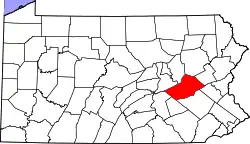 Karte von Schuylkill County innerhalb von Pennsylvania | |
| Website: www.co.schuylkill.pa.us | |
Geschichte

Das County wurde am 1. März 1811 gebildet und nach dem Schuylkill River benannt.[3]
18 Bauwerke und Stätten des Countys sind im National Register of Historic Places (NRHP) eingetragen (Stand 24. Juli 2018).[4]
Geographie
Das County hat eine Fläche von 2027 Quadratkilometern, wovon 11 Quadratkilometer Wasserfläche sind.
Städte und Gemeinden
| Bevölkerungsentwicklung | |||
|---|---|---|---|
| Census | Einwohner | ± in % | |
| 1900 | 172.927 | — | |
| 1910 | 207.894 | 20,2 % | |
| 1920 | 217.754 | 4,7 % | |
| 1930 | 235.505 | 8,2 % | |
| 1940 | 228.331 | −3 % | |
| 1950 | 200.577 | −12,2 % | |
| 1960 | 173.027 | −13,7 % | |
| 1970 | 160.089 | −7,5 % | |
| 1980 | 160.630 | 0,3 % | |
| 1990 | 152.585 | −5 % | |
| 2000 | 150.336 | −1,5 % | |
| 2010 | 148.289 | −1,4 % | |
| 2020 | 143.049 | −3,5 % | |
| 1900–1990[5]
2000[6] 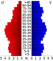 Alterspyramide des Schuylkill Countys (Stand: 2000) | |||
|
|
|
Einzelnachweise
- Schuylkill County im Geographic Names Information System des United States Geological Survey. Abgerufen am 22. Februar 2011
- U.S. Census Bureau QuickFacts: Schuylkill County, Pennsylvania. Abgerufen am 28. August 2021 (englisch).
- Charles Curry Aiken, Joseph Nathan Kane: The American Counties: Origins of County Names, Dates of Creation, Area, and Population Data, 1950–2010. 6. Auflage. Scarecrow Press, Lanham 2013, ISBN 978-0-8108-8762-6, S. 276.
- Suchmaske Datenbank im National Register Information System. National Park Service, abgerufen am 24. Juli 2018.
- Auszug aus Census.gov. Abgerufen am 28. Februar 2011
- Auszug aus factfinder.census.gov Abgerufen am 28. Februar 2011
Weblinks
Liste der Countys in Pennsylvania
Adams |
Allegheny |
Armstrong |
Beaver |
Bedford |
Berks |
Blair |
Bradford |
Bucks |
Butler |
Cambria |
Cameron |
Carbon |
Centre |
Chester |
Clarion |
Clearfield |
Clinton |
Columbia |
Crawford |
Cumberland |
Dauphin |
Delaware |
Elk |
Erie |
Fayette |
Forest |
Franklin |
Fulton |
Greene |
Huntingdon |
Indiana |
Jefferson |
Juniata |
Lackawanna |
Lancaster |
Lawrence |
Lebanon |
Lehigh |
Luzerne |
Lycoming |
McKean |
Mercer |
Mifflin |
Monroe |
Montgomery |
Montour |
Northampton |
Northumberland |
Perry |
Philadelphia |
Pike |
Potter |
Schuylkill |
Snyder |
Somerset |
Sullivan |
Susquehanna |
Tioga |
Union |
Venango |
Warren |
Washington |
Wayne |
Westmoreland |
Wyoming |
York