Armstrong County (Pennsylvania)
Armstrong County[1] ist ein County im Bundesstaat Pennsylvania der Vereinigten Staaten. Bei der Volkszählung im Jahr 2020 hatte das County 65.558 Einwohner und eine Bevölkerungsdichte von 43 Einwohner pro Quadratkilometer.[2] Der Verwaltungssitz (County Seat) ist Kittanning.
 Armstrong County Courthouse | |
| Verwaltung | |
|---|---|
| US-Bundesstaat: | Pennsylvania |
| Verwaltungssitz: | Kittanning |
| Gründung: | 12. März 1800 |
| Gebildet aus: | Allegheny County Lycoming County Westmoreland County |
| Vorwahl: | 001 724 |
| Demographie | |
| Einwohner: | 65.558 (2020) |
| Bevölkerungsdichte: | 38,7 Einwohner/km2 |
| Geographie | |
| Fläche gesamt: | 1721 km² |
| Wasserfläche: | 27 km² |
| Karte | |
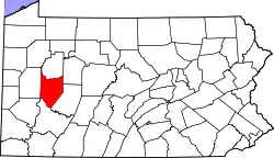 Karte von Armstrong County innerhalb von Pennsylvania | |
| Website: www.co.armstrong.pa.us | |
Geographie
Das County hat eine Fläche von 1721 Quadratkilometern, wovon 27 Quadratkilometer Wasserfläche sind. Armstrong County grenzt im Uhrzeigersinn an folgende Countys: Clarion County, Jefferson County, Indiana County, Westmoreland County, Allegheny County und Butler County.
Geschichte
Das County wurde am 12. Mai 1800 gebildet und nach dem Militär und Politiker John Armstrong junior benannt.[3]
14 Bauwerke und Stätten des Countys sind im National Register of Historic Places (NRHP) eingetragen (Stand 20. Juli 2018).[4]
Bevölkerungsentwicklung
| Bevölkerungsentwicklung | |||
|---|---|---|---|
| Census | Einwohner | ± in % | |
| 1900 | 52.551 | — | |
| 1910 | 67.880 | 29,2 % | |
| 1920 | 75.568 | 11,3 % | |
| 1930 | 79.298 | 4,9 % | |
| 1940 | 81.087 | 2,3 % | |
| 1950 | 80.842 | −0,3 % | |
| 1960 | 79.524 | −1,6 % | |
| 1970 | 75.590 | −4,9 % | |
| 1980 | 77.768 | 2,9 % | |
| 1990 | 73.478 | −5,5 % | |
| 2000 | 72.392 | −1,5 % | |
| 2010 | 68.941 | −4,8 % | |
| 2020 | 65.558 | −4,9 % | |
| 1900–1990[5]
2000[6] | |||
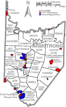
Städte und Ortschaften
|
|
|
Medien
- WTYM, Radiosender
Einzelnachweise
- Armstrong County im Geographic Names Information System des United States Geological Survey. Abgerufen am 22. Februar 2011
- U.S. Census Bureau QuickFacts: Armstrong County, Pennsylvania. Abgerufen am 25. August 2021 (englisch).
- Charles Curry Aiken, Joseph Nathan Kane: The American Counties: Origins of County Names, Dates of Creation, Area, and Population Data, 1950–2010. 6. Auflage. Scarecrow Press, Lanham 2013, ISBN 978-0-8108-8762-6, S. 10.
- Suchmaske Datenbank im National Register Information System. National Park Service, abgerufen am 20. Juli 2018.
- Auszug aus Census.gov. Abgerufen am 28. Februar 2011
- Auszug aus factfinder.census.gov Abgerufen am 28. Februar 2011
Weblinks
Liste der Countys in Pennsylvania
Adams |
Allegheny |
Armstrong |
Beaver |
Bedford |
Berks |
Blair |
Bradford |
Bucks |
Butler |
Cambria |
Cameron |
Carbon |
Centre |
Chester |
Clarion |
Clearfield |
Clinton |
Columbia |
Crawford |
Cumberland |
Dauphin |
Delaware |
Elk |
Erie |
Fayette |
Forest |
Franklin |
Fulton |
Greene |
Huntingdon |
Indiana |
Jefferson |
Juniata |
Lackawanna |
Lancaster |
Lawrence |
Lebanon |
Lehigh |
Luzerne |
Lycoming |
McKean |
Mercer |
Mifflin |
Monroe |
Montgomery |
Montour |
Northampton |
Northumberland |
Perry |
Philadelphia |
Pike |
Potter |
Schuylkill |
Snyder |
Somerset |
Sullivan |
Susquehanna |
Tioga |
Union |
Venango |
Warren |
Washington |
Wayne |
Westmoreland |
Wyoming |
York