Lycoming County
Lycoming County[1] ist ein County im US-Bundesstaat Pennsylvania der Vereinigten Staaten. Bei der Volkszählung im Jahr 2020 hatte der County 114.188 Einwohner und eine Bevölkerungsdichte von 36 Einwohner pro Quadratkilometer.[2] Der Verwaltungssitz (County Seat) ist Williamsport.
 Das Lycoming County Courthouse in Williamsport | |
| Verwaltung | |
|---|---|
| US-Bundesstaat: | Pennsylvania |
| Verwaltungssitz: | Williamsport |
| Gründung: | 13. April 1795 |
| Gebildet aus: | Northumberland County |
| Vorwahl: | 001 570 |
| Demographie | |
| Einwohner: | 114.188 (2020) |
| Bevölkerungsdichte: | 35,71 Einwohner/km2 |
| Geographie | |
| Fläche gesamt: | 3221 km² |
| Wasserfläche: | 23 km² |
| Karte | |
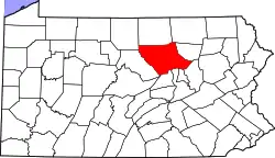 Karte von Lycoming County innerhalb von Pennsylvania | |
| Website: www.lyco.org | |
Geschichte
Spuren altamerikanischer Besiedlung finden sich im Canfield Island Site.
Das County wurde am 13. April 1795 gebildet und nach dem Lycoming Creek benannt, einem Zufluss des Susquehanna River.[3]
19 Bauwerke und Stätten des Countys sind im National Register of Historic Places (NRHP) eingetragen (Stand 23. Juli 2018).[4]
Geographie
Das County hat eine Fläche von 3221 Quadratkilometern, davon sind 23 Quadratkilometer Wasserfläche.
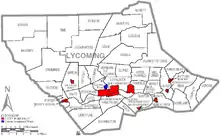
Städte und Ortschaften
| Bevölkerungsentwicklung | |||
|---|---|---|---|
| Census | Einwohner | ± in % | |
| 1800 | 5414 | — | |
| 1810 | 11.006 | 103,3 % | |
| 1820 | 13.517 | 22,8 % | |
| 1830 | 17.636 | 30,5 % | |
| 1840 | 22.649 | 28,4 % | |
| 1850 | 26.257 | 15,9 % | |
| 1860 | 37.399 | 42,4 % | |
| 1870 | 47.626 | 27,3 % | |
| 1880 | 57.486 | 20,7 % | |
| 1890 | 70.579 | 22,8 % | |
| 1900 | 75.663 | 7,2 % | |
| 1910 | 80.813 | 6,8 % | |
| 1920 | 83.100 | 2,8 % | |
| 1930 | 93.421 | 12,4 % | |
| 1940 | 93.633 | 0,2 % | |
| 1950 | 101.249 | 8,1 % | |
| 1960 | 109.367 | 8 % | |
| 1970 | 113.296 | 3,6 % | |
| 1980 | 118.416 | 4,5 % | |
| 1990 | 118.710 | 0,2 % | |
| 2000 | 120.044 | 1,1 % | |
| 2010 | 116.111 | −3,3 % | |
| 2020 | 114.188 | −1,7 % | |
| Vor 1900[5] | |||
|
|
|
Sehenswürdigkeiten
- Buttonwood Covered Bridge in Jackson Township
Einzelnachweise
- Lycoming County im Geographic Names Information System des United States Geological Survey. Abgerufen am 22. Februar 2011
- U.S. Census Bureau QuickFacts: Lycoming County, Pennsylvania. Abgerufen am 28. August 2021 (englisch).
- Charles Curry Aiken, Joseph Nathan Kane: The American Counties: Origins of County Names, Dates of Creation, Area, and Population Data, 1950–2010. 6. Auflage. Scarecrow Press, Lanham 2013, ISBN 978-0-8108-8762-6, S. 187.
- Suchmaske Datenbank im National Register Information System. National Park Service, abgerufen am 23. Juli 2018.
- U.S. Census Bureau _ Census of Population and Housing. Abgerufen am 28. Februar 2011
- Auszug aus Census.gov. Abgerufen am 28. Februar 2011
- Auszug aus factfinder.census.gov Abgerufen am 28. Februar 2011
Weblinks
Liste der Countys in Pennsylvania
Adams |
Allegheny |
Armstrong |
Beaver |
Bedford |
Berks |
Blair |
Bradford |
Bucks |
Butler |
Cambria |
Cameron |
Carbon |
Centre |
Chester |
Clarion |
Clearfield |
Clinton |
Columbia |
Crawford |
Cumberland |
Dauphin |
Delaware |
Elk |
Erie |
Fayette |
Forest |
Franklin |
Fulton |
Greene |
Huntingdon |
Indiana |
Jefferson |
Juniata |
Lackawanna |
Lancaster |
Lawrence |
Lebanon |
Lehigh |
Luzerne |
Lycoming |
McKean |
Mercer |
Mifflin |
Monroe |
Montgomery |
Montour |
Northampton |
Northumberland |
Perry |
Philadelphia |
Pike |
Potter |
Schuylkill |
Snyder |
Somerset |
Sullivan |
Susquehanna |
Tioga |
Union |
Venango |
Warren |
Washington |
Wayne |
Westmoreland |
Wyoming |
York