Clarion County
Clarion County[1] ist ein County im US-Bundesstaat Pennsylvania der Vereinigten Staaten. Bei der Volkszählung im Jahr 2020 hatte das County 37.241 Einwohner und eine Bevölkerungsdichte von 24 Einwohner pro Quadratkilometer. Der Verwaltungssitz (County Seat) ist Clarion.[2]
 Clarion County Courthouse | |
| Verwaltung | |
|---|---|
| US-Bundesstaat: | Pennsylvania |
| Verwaltungssitz: | Clarion |
| Adresse des Verwaltungssitzes: |
Clarion County Courthouse 421 Main Street Clarion, PA 16214 |
| Gründung: | 11. März 1839 |
| Gebildet aus: | Venango County Armstrong County |
| Vorwahl: | 001 814 |
| Demographie | |
| Einwohner: | 37.241 (2020) |
| Bevölkerungsdichte: | 24,28 Einwohner/km2 |
| Geographie | |
| Fläche gesamt: | 1557 km² |
| Wasserfläche: | 23 km² |
| Karte | |
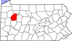 Karte von Clarion County innerhalb von Pennsylvania | |
| Website: www.co.clarion.pa.us | |
Geographie
Das County hat eine Fläche von 1557 Quadratkilometern, wovon 23 Quadratkilometer Wasserfläche sind.
Geschichte
Das County wurde am 11. März 1839 aus Teilen des Venango County sowie Armstrong County gebildet und ist nach dem Clarion River benannt.[3]
Vier Bauwerke und Stätten des Countys sind im National Register of Historic Places (NRHP) eingetragen (Stand 22. Juli 2018).[4]
Orte im Clarion County
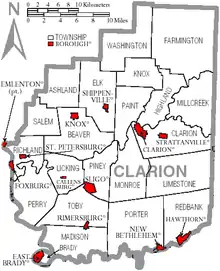
Das Clarion County ist unterteilt in 35 Gemeinden, davon 13 Boroughs und 22 Townships. Zu Statistikzwecken führt das U.S. Census Bureau fünf Census-designated places. Diese sind Teil eines Townships und haben keine Selbstverwaltung.
| Bevölkerungsentwicklung | |||
|---|---|---|---|
| Census | Einwohner | ± in % | |
| 1850 | 23.565 | — | |
| 1860 | 24.988 | 6 % | |
| 1870 | 26.537 | 6,2 % | |
| 1880 | 40.328 | 52 % | |
| 1890 | 36.802 | −8,7 % | |
| 1900 | 34.283 | −6,8 % | |
| 1910 | 36.638 | 6,9 % | |
| 1920 | 36.170 | −1,3 % | |
| 1930 | 34.531 | −4,5 % | |
| 1940 | 38.410 | 11,2 % | |
| 1950 | 38.344 | −0,2 % | |
| 1960 | 37.408 | −2,4 % | |
| 1970 | 38.414 | 2,7 % | |
| 1980 | 43.362 | 12,9 % | |
| 1990 | 41.699 | −3,8 % | |
| 2000 | 41.765 | 0,2 % | |
| 2010 | 39.988 | −4,3 % | |
| 2020 | 37.241 | −6,9 % | |
| 1850–1990[5]
2000[6] | |||
|
|
|
|
|
Census-designated places (CDP)
|
|
1größtenteils im Venango County
Einzelnachweise
- Clarion County im Geographic Names Information System des United States Geological Survey. Abgerufen am 22. Februar 2011
- U.S. Census Bureau QuickFacts: Clarion County, Pennsylvania. Abgerufen am 28. August 2021 (englisch).
- Charles Curry Aiken, Joseph Nathan Kane: The American Counties: Origins of County Names, Dates of Creation, Area, and Population Data, 1950–2010. 6. Auflage. Scarecrow Press, Lanham 2013, ISBN 978-0-8108-8762-6, S. 58.
- Suchmaske Datenbank im National Register Information System. National Park Service, abgerufen am 22. Juli 2018.
- Population of States and Counties of the United States: 1790 to 1990 U.S. Census Bureau
- Auszug aus factfinder.census.gov Abgerufen am 28. Februar 2011
Weblinks
Liste der Countys in Pennsylvania
Adams |
Allegheny |
Armstrong |
Beaver |
Bedford |
Berks |
Blair |
Bradford |
Bucks |
Butler |
Cambria |
Cameron |
Carbon |
Centre |
Chester |
Clarion |
Clearfield |
Clinton |
Columbia |
Crawford |
Cumberland |
Dauphin |
Delaware |
Elk |
Erie |
Fayette |
Forest |
Franklin |
Fulton |
Greene |
Huntingdon |
Indiana |
Jefferson |
Juniata |
Lackawanna |
Lancaster |
Lawrence |
Lebanon |
Lehigh |
Luzerne |
Lycoming |
McKean |
Mercer |
Mifflin |
Monroe |
Montgomery |
Montour |
Northampton |
Northumberland |
Perry |
Philadelphia |
Pike |
Potter |
Schuylkill |
Snyder |
Somerset |
Sullivan |
Susquehanna |
Tioga |
Union |
Venango |
Warren |
Washington |
Wayne |
Westmoreland |
Wyoming |
York