Montchenu
Montchenu ist eine französische Gemeinde mit 581 Einwohnern (Stand 1. Januar 2019) im Département Drôme in der Region Auvergne-Rhône-Alpes; sie gehört zum Arrondissement Valence und zum Kanton Drôme des collines.
| Montchenu | ||
|---|---|---|
| ||
| Staat | Frankreich | |
| Region | Auvergne-Rhône-Alpes | |
| Département (Nr.) | Drôme (26) | |
| Arrondissement | Valence | |
| Kanton | Drôme des collines | |
| Gemeindeverband | Hermitage-Tournonais-Herbasse-Pays de Saint Félicien | |
| Koordinaten | 45° 12′ N, 5° 2′ O | |
| Höhe | 263–489 m | |
| Fläche | 16,48 km² | |
| Einwohner | 581 (1. Januar 2019) | |
| Bevölkerungsdichte | 35 Einw./km² | |
| Postleitzahl | 26350 | |
| INSEE-Code | 26194 | |
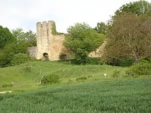 Burg Montchenu | ||

Nachbargemeinden von Montchenu sind Tersanne, Bathernay, Saint-Christophe-et-le-Laris, Crépol und Margès.
Bevölkerungsentwicklung
| Jahr | 1962 | 1968 | 1975 | 1982 | 1990 | 1999 | 2008 | 2016 |
| Einwohner | 399 | 455 | 386 | 381 | 389 | 456 | 564 | 581 |
| Quellen: Cassini und INSEE | ||||||||
Sehenswürdigkeiten
- Burg Montchenu
- Zwei Türme aus dem 13./14. Jahrhundert in Saint-Mury
Weblinks
Commons: Montchenu – Sammlung von Bildern, Videos und Audiodateien
This article is issued from Wikipedia. The text is licensed under Creative Commons - Attribution - Sharealike. The authors of the article are listed here. Additional terms may apply for the media files, click on images to show image meta data.