Les Étilleux
Les Étilleux ist eine französische Gemeinde mit 212 Einwohnern (Stand: 1. Januar 2019) im Département Eure-et-Loir in der Region Centre-Val de Loire; sie gehört zum Arrondissement Nogent-le-Rotrou und zum Kanton Brou (bis 2015: Kanton Authon-du-Perche).
| Les Étilleux | ||
|---|---|---|
| ||
| Staat | Frankreich | |
| Region | Centre-Val de Loire | |
| Département (Nr.) | Eure-et-Loir (28) | |
| Arrondissement | Nogent-le-Rotrou | |
| Kanton | Brou | |
| Gemeindeverband | Perche | |
| Koordinaten | 48° 14′ N, 0° 49′ O | |
| Höhe | 162–265 m | |
| Fläche | 8,44 km² | |
| Einwohner | 212 (1. Januar 2019) | |
| Bevölkerungsdichte | 25 Einw./km² | |
| Postleitzahl | 28330 | |
| INSEE-Code | 28144 | |

Geographie
Les Étilleux liegt etwa 55 Kilometer westsüdwestlich von Chartres in der Perche. Umgeben wird Les Étilleux von den Nachbargemeinden Souancé-au-Perche im Norden und Nordosten, Coudray-au-Perche im Osten und Südosten, Saint-Bomer im Süden, Ceton im Westen und Südwesten sowie Mâle im Nordwesten.
Bevölkerungsentwicklung
| Jahr | 1962 | 1968 | 1975 | 1982 | 1990 | 1999 | 2006 | 2013 |
| Einwohner | 247 | 233 | 200 | 168 | 184 | 188 | 188 | 233 |
| Quelle: Cassini und INSEE | ||||||||
Sehenswürdigkeiten
- Kirche Notre-Dame von 1214, seit 2003 Monument historique
- Schloss Le Grand Fresnay, 1480 erbaut, seit 1978 Monument historique
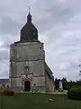 Kirche Notre-Dame
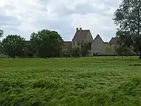 Schloss Le Grand Fresnay
Weblinks
Commons: Les Étilleux – Sammlung von Bildern, Videos und Audiodateien
This article is issued from Wikipedia. The text is licensed under Creative Commons - Attribution - Sharealike. The authors of the article are listed here. Additional terms may apply for the media files, click on images to show image meta data.