La Gaudaine
La Gaudaine ist eine französische Gemeinde mit 169 Einwohnern (Stand: 1. Januar 2019) im Département Eure-et-Loir in der Region Centre-Val de Loire; sie gehört zum Arrondissement Nogent-le-Rotrou und zum Kanton Nogent-le-Rotrou.
| La Gaudaine | ||
|---|---|---|
| ||
| Staat | Frankreich | |
| Region | Centre-Val de Loire | |
| Département (Nr.) | Eure-et-Loir (28) | |
| Arrondissement | Nogent-le-Rotrou | |
| Kanton | Nogent-le-Rotrou | |
| Gemeindeverband | Terres de Perche | |
| Koordinaten | 48° 18′ N, 0° 56′ O | |
| Höhe | 190–286 m | |
| Fläche | 9,19 km² | |
| Einwohner | 169 (1. Januar 2019) | |
| Bevölkerungsdichte | 18 Einw./km² | |
| Postleitzahl | 28400 | |
| INSEE-Code | 28175 | |

Geographie
La Gaudaine liegt etwa 47 Kilometer westsüdwestlich von Chartres. Umgeben wird La Gaudaine von den Nachbargemeinden Arcisses mit Brunelles im Norden und Nordwesten, Thiron-Gardais im Osten und Nordosten, La Croix-du-Perche im Südosten, Argenvilliers im Süden, Vichères im Südwesten, Trizay-Coutretot-Saint-Serge im Westen und Südwesten sowie Champrond-en-Perchet im Westen und Nordwesten.
Bevölkerungsentwicklung
| Jahr | 1962 | 1968 | 1975 | 1982 | 1990 | 1999 | 2006 | 2013 |
| Einwohner | 166 | 112 | 104 | 108 | 128 | 154 | 180 | 173 |
| Quelle: Cassini und INSEE | ||||||||
Sehenswürdigkeiten
- Kirche Notre-Dame
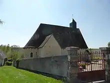
Kirche Saint-Jean-Baptiste
Weblinks
Commons: La Gaudaine – Sammlung von Bildern, Videos und Audiodateien
This article is issued from Wikipedia. The text is licensed under Creative Commons - Attribution - Sharealike. The authors of the article are listed here. Additional terms may apply for the media files, click on images to show image meta data.