Charbonnières (Eure-et-Loir)
Charbonnières ist eine französische Gemeinde mit 206 Einwohnern (Stand: 1. Januar 2019) im Département Eure-et-Loir in der Region Centre-Val de Loire; sie gehört zum Arrondissement Nogent-le-Rotrou und zum Kanton Brou (bis 2015: Kanton Authon-du-Perche). Die Einwohner werden Soizéens genannt.
| Charbonnières | ||
|---|---|---|
| ||
| Staat | Frankreich | |
| Region | Centre-Val de Loire | |
| Département (Nr.) | Eure-et-Loir (28) | |
| Arrondissement | Nogent-le-Rotrou | |
| Kanton | Brou | |
| Gemeindeverband | Perche | |
| Koordinaten | 48° 12′ N, 0° 56′ O | |
| Höhe | 192–245 m | |
| Fläche | 21,08 km² | |
| Einwohner | 254 (1. Januar 2019) | |
| Bevölkerungsdichte | 12 Einw./km² | |
| Postleitzahl | 28330 | |
| INSEE-Code | 28080 | |

Geographie
Charbonnières liegt etwa 50 Kilometer südwestlich von Chartres in der Perche. Umgeben wird Charbonnières von den Nachbargemeinden
- Authon-du-Perche mit Soizé im Südwesten und Authon-du-Perche im Norden und Westen,
- Beaumont-les-Autels im Norden,
- Moulhard im Nordosten,
- Unverre im Osten,
- Les Autels-Villevillon im Südosten,
- La Bazoche-Gouet im Süden.
Bevölkerungsentwicklung
| Jahr | 1962 | 1968 | 1975 | 1982 | 1990 | 1999 | 2006 | 2013 |
| Einwohner | 514 | 455 | 404 | 311 | 258 | 260 | 257 | 257 |
| Quelle: Cassini und INSEE | ||||||||
Sehenswürdigkeiten
- Kirche Saint-Jean-Baptiste
- Schloss Charbonnières aus dem 15. Jahrhundert
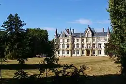
Schloss Charbonnières
Weblinks
Commons: Charbonnières – Sammlung von Bildern, Videos und Audiodateien
This article is issued from Wikipedia. The text is licensed under Creative Commons - Attribution - Sharealike. The authors of the article are listed here. Additional terms may apply for the media files, click on images to show image meta data.