Vaupillon
Vaupillon ist eine französische Gemeinde mit 454 Einwohnern (Stand: 1. Januar 2019) im Département Eure-et-Loir in der Region Centre-Val de Loire; sie gehört zum Arrondissement Nogent-le-Rotrou und zum Kanton Nogent-le-Rotrou (bis 2015: Kanton La Loupe).
| Vaupillon | ||
|---|---|---|
| ||
| Staat | Frankreich | |
| Region | Centre-Val de Loire | |
| Département (Nr.) | Eure-et-Loir (28) | |
| Arrondissement | Nogent-le-Rotrou | |
| Kanton | Nogent-le-Rotrou | |
| Gemeindeverband | Terres de Perche | |
| Koordinaten | 48° 27′ N, 1° 0′ O | |
| Höhe | 174–219 m | |
| Fläche | 12,70 km² | |
| Einwohner | 454 (1. Januar 2019) | |
| Bevölkerungsdichte | 36 Einw./km² | |
| Postleitzahl | 28240 | |
| INSEE-Code | 28401 | |
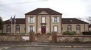 Rathaus (Mairie) und Schule von Vaupillon | ||

Geographie
Vaupillon liegt etwa 45 Kilometer westnordwestlich von Chartres. Umgeben wird Vaupillon von den Nachbargemeinden Meaucé im Norden, La Loupe im Nordosten, Saint-Éliph im Osten, Saint-Victor-de-Buthon im Süden sowie Bretoncelles im Süden und Westen.
Bevölkerungsentwicklung
| Jahr | 1962 | 1968 | 1975 | 1982 | 1990 | 1999 | 2006 | 2013 |
| Einwohner | 444 | 439 | 375 | 375 | 374 | 394 | 461 | 450 |
| Quelle: Cassini und INSEE | ||||||||
Sehenswürdigkeiten
- Kirche Notre-Dame aus dem 16. Jahrhundert

Kirche Notre-Dame
Weblinks
Commons: Vaupillon – Sammlung von Bildern, Videos und Audiodateien
This article is issued from Wikipedia. The text is licensed under Creative Commons - Attribution - Sharealike. The authors of the article are listed here. Additional terms may apply for the media files, click on images to show image meta data.