Langy
Langy ist eine französische Gemeinde mit 271 Einwohnern (Stand 1. Januar 2019) im Département Allier in der Region Auvergne-Rhône-Alpes (vor 2016 Auvergne). Sie gehört zum Arrondissement Vichy und zum Kanton Saint-Pourçain-sur-Sioule.
| Langy | ||
|---|---|---|
| ||
| Staat | Frankreich | |
| Region | Auvergne-Rhône-Alpes | |
| Département (Nr.) | Allier (03) | |
| Arrondissement | Vichy | |
| Kanton | Saint-Pourçain-sur-Sioule | |
| Gemeindeverband | Entr’Allier Besbre et Loire | |
| Koordinaten | 46° 16′ N, 3° 28′ O | |
| Höhe | 260–342 m | |
| Fläche | 7,36 km² | |
| Einwohner | 271 (1. Januar 2019) | |
| Bevölkerungsdichte | 37 Einw./km² | |
| Postleitzahl | 03150 | |
| INSEE-Code | 03137 | |
| Website | http://langy.interco-abl.fr/ | |

Geografie
Langy liegt etwa 18 Kilometer nordnordöstlich von Vichy. Umgeben wird Langy von den Nachbargemeinden Rongères im Norden, Boucé im Nordosten, Saint-Gérand-le-Puy im Osten und Südosten, Sanssat im Süden sowie Créchy im Westen.
Durch die Gemeinde führt die Route nationale 7.
Bevölkerungsentwicklung
| Jahr | 1962 | 1968 | 1975 | 1982 | 1990 | 1999 | 2006 | 2011 | 2019 |
| Einwohner | 300 | 259 | 227 | 187 | 194 | 218 | 233 | 251 | 271 |
| Quellen: Cassini und INSEE | |||||||||
Sehenswürdigkeiten
- Kirche Saint-Sulpice aus dem 11. Jahrhundert
- Herrenhaus La Font aus dem 15. Jahrhundert
Siehe auch: Liste der Monuments historiques in Langy
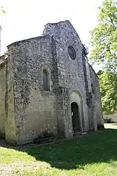
Kirche Saint-Sulpice
Literatur
- Le Patrimoine des Communes de l’Allier. Flohic Editions, Band 1, Paris 1999, ISBN 2-84234-053-1, S. 1024–1026.
This article is issued from Wikipedia. The text is licensed under Creative Commons - Attribution - Sharealike. The authors of the article are listed here. Additional terms may apply for the media files, click on images to show image meta data.