Kanton Meung-sur-Loire
Der Kanton Meung-sur-Loire ist ein französischer Kanton im Arrondissement Orléans, im Département Loiret und in der Region Centre-Val de Loire. Sein Hauptort ist Meung-sur-Loire. Vertreter im Generalrat des Départements ist seit 1985 Éric Doligé (UMP).
| Kanton Meung-sur-Loire | |
|---|---|
| Region | Centre-Val de Loire |
| Département | Loiret |
| Arrondissement | Orléans |
| Hauptort | Meung-sur-Loire |
| Einwohner | 36.356 (1. Jan. 2019) |
| Bevölkerungsdichte | 62 Einw./km² |
| Fläche | 590,88 km² |
| Gemeinden | 32 |
| INSEE-Code | 4510 |
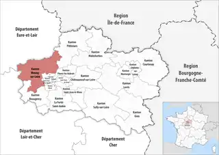 Lage des Kantons Meung-sur-Loire im Département Loiret | |
Gemeinden
Der Kanton besteht aus 32 Gemeinden mit insgesamt 36.356 Einwohnern (Stand: 1. Januar 2019) auf einer Gesamtfläche von 590,88 km²:
| Gemeinde | Einwohner 1. Januar 2019 |
Fläche km² |
Dichte Einw./km² |
Code INSEE |
Postleitzahl |
|---|---|---|---|---|---|
| Artenay | 1.951 | 20,48 | 95 | 45008 | 45410 |
| Boulay-les-Barres | 1.053 | 12,33 | 85 | 45046 | 45140 |
| Bricy | 554 | 12,69 | 44 | 45055 | 45310 |
| Bucy-le-Roi | 176 | 4,66 | 38 | 45058 | 45410 |
| Bucy-Saint-Liphard | 193 | 17,84 | 11 | 45059 | 45140 |
| Cercottes | 1.491 | 24,25 | 61 | 45062 | 45520 |
| Chaingy | 3.881 | 21,65 | 179 | 45067 | 45380 |
| Charsonville | 613 | 24,64 | 25 | 45081 | 45130 |
| Chevilly | 2.658 | 42,24 | 63 | 45093 | 45520 |
| Coinces | 516 | 21,93 | 24 | 45099 | 45310 |
| Coulmiers | 541 | 14,21 | 38 | 45109 | 45130 |
| Épieds-en-Beauce | 1.430 | 40,27 | 36 | 45134 | 45130 |
| Gémigny | 211 | 14,55 | 15 | 45152 | 45310 |
| Gidy | 2.057 | 23,47 | 88 | 45154 | 45520 |
| Huêtre | 284 | 13,24 | 21 | 45166 | 45520 |
| Huisseau-sur-Mauves | 1.704 | 37,04 | 46 | 45167 | 45130 |
| La Chapelle-Onzerain | 115 | 7,24 | 16 | 45074 | 45310 |
| Le Bardon | 987 | 12,34 | 80 | 45020 | 45130 |
| Lion-en-Beauce | 139 | 7,03 | 20 | 45183 | 45410 |
| Meung-sur-Loire | 6.540 | 20,23 | 323 | 45203 | 45130 |
| Patay | 2.244 | 13,95 | 161 | 45248 | 45310 |
| Rouvray-Sainte-Croix | 140 | 9,51 | 15 | 45262 | 45310 |
| Rozières-en-Beauce | 185 | 9,18 | 20 | 45264 | 45130 |
| Ruan | 204 | 16,40 | 12 | 45266 | 45410 |
| Saint-Ay | 3.561 | 10,30 | 346 | 45269 | 45130, 45380 |
| Saint-Péravy-la-Colombe | 752 | 19,28 | 39 | 45296 | 45310 |
| Saint-Sigismond | 267 | 14,58 | 18 | 45299 | 45310 |
| Sougy | 814 | 28,04 | 29 | 45313 | 45410 |
| Tournoisis | 392 | 15,22 | 26 | 45326 | 45310 |
| Trinay | 217 | 17,42 | 12 | 45330 | 45410 |
| Villamblain | 286 | 26,61 | 11 | 45337 | 45310 |
| Villeneuve-sur-Conie | 200 | 18,06 | 11 | 45341 | 45310 |
| Kanton Meung-sur-Loire | 36.356 | 590,88 | 62 | 4510 | – |
Bis zur landesweiten Neugliederung der Kantone 2015 bestand der Kanton Meung-sur-Loire aus den zehn Gemeinden Baccon, Le Bardon, Chaingy, Charsonville, Coulmiers, Épieds-en-Beauce, Huisseau-sur-Mauves, Meung-sur-Loire, Rozières-en-Beauce und Saint-Ay. Sein Zuschnitt entsprach einer Fläche von 222,74 km2. Er besaß vor 2015 einen anderen INSEE-Code als heute, nämlich 4518.
Geschichte
Die Schlacht bei Coulmiers am 9. November 1870 war eine Episode im Deutsch-Französischen Krieg von 1870/1871.