Irais
Irais ist eine französische Gemeinde mit 208 Einwohnern (Stand: 1. Januar 2019) im Département Deux-Sèvres in der Region Nouvelle-Aquitaine. Sie gehört zum Arrondissement Parthenay und zum Kanton Le Val de Thouet (bis 2015: Kanton Airvault).
| Irais | ||
|---|---|---|
| ||
| Staat | Frankreich | |
| Region | Nouvelle-Aquitaine | |
| Département (Nr.) | Deux-Sèvres (79) | |
| Arrondissement | Parthenay | |
| Kanton | Le Val de Thouet | |
| Gemeindeverband | Airvaudais-Val du Thouet | |
| Koordinaten | 46° 53′ N, 0° 6′ W | |
| Höhe | 74–137 m | |
| Fläche | 13,55 km² | |
| Einwohner | 208 (1. Januar 2019) | |
| Bevölkerungsdichte | 15 Einw./km² | |
| Postleitzahl | 79600 | |
| INSEE-Code | 79141 | |

Lage
Irais liegt etwa 30 Kilometer ostnordöstlich von Bressuire und etwa 28 Kilometer nordnordöstlich von Parthenay. Umgeben wird Irais von den Nachbargemeinden Oiron im Norden, Saint-Jouin-de-Marnes im Osten, Airvault im Süden, Availles-Thouarsais im Südwesten sowie Saint-Généroux im Westen.
Bevölkerungsentwicklung
| Jahr | 1962 | 1968 | 1975 | 1982 | 1990 | 1999 | 2006 | 2013 |
| Einwohner | 338 | 322 | 265 | 274 | 235 | 225 | 226 | 201 |
| Quelle: Cassini und INSEE | ||||||||
Sehenswürdigkeiten
- Kirche Saint-Paul
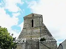
Kirche Saint-Paul
This article is issued from Wikipedia. The text is licensed under Creative Commons - Attribution - Sharealike. The authors of the article are listed here. Additional terms may apply for the media files, click on images to show image meta data.