Châtillon-sur-Thouet
Châtillon-sur-Thouet ist eine französische Gemeinde mit 2.678 Einwohnern (Stand: 1. Januar 2019) im Département Deux-Sèvres in der Region Nouvelle-Aquitaine. Die Gemeinde gehört zum Arrondissement Parthenay und zum Kanton Parthenay.
| Châtillon-sur-Thouet | ||
|---|---|---|
| ||
| Staat | Frankreich | |
| Region | Nouvelle-Aquitaine | |
| Département (Nr.) | Deux-Sèvres (79) | |
| Arrondissement | Parthenay | |
| Kanton | Parthenay | |
| Gemeindeverband | Parthenay-Gâtine | |
| Koordinaten | 46° 40′ N, 0° 14′ W | |
| Höhe | 117–186 m | |
| Fläche | 16,25 km² | |
| Einwohner | 2.678 (1. Januar 2019) | |
| Bevölkerungsdichte | 165 Einw./km² | |
| Postleitzahl | 79200 | |
| INSEE-Code | 79080 | |

Geografie
Die Gemeinde liegt am Fluss Thouet unmittelbar nordöstlich von Parthenay. Umgeben wird Châtillon-sur-Thouet von den Nachbargemeinden Viennay im Norden, La Peyratte im Osten, Parthenay im Süden und Südosten, Le Tallud im Südwesten, Saint-Aubin-le-Cloud im Westen und Südwesten sowie Adilly und Amailloux im Nordwesten.
Durch die Gemeinde führt die Route nationale 149.
Bevölkerungsentwicklung
| Jahr | 1962 | 1968 | 1975 | 1982 | 1990 | 1999 | 2006 | 2012 |
| Einwohner | 898 | 1.306 | 2.323 | 2.874 | 2.769 | 2.727 | 2.865 | 2.764 |
Sehenswürdigkeiten
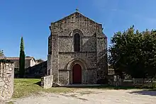
Kirche
- Kirche
This article is issued from Wikipedia. The text is licensed under Creative Commons - Attribution - Sharealike. The authors of the article are listed here. Additional terms may apply for the media files, click on images to show image meta data.