Hesdigneul-lès-Boulogne
Hesdigneul-lès-Boulogne ist eine französische Gemeinde mit 718 Einwohnern (Stand: 1. Januar 2019) im Département Pas-de-Calais in der Region Hauts-de-France (vor 2016 Nord-Pas-de-Calais). Sie gehört zum Arrondissement Boulogne-sur-Mer und zum Kanton Outreau (bis 2015 Kanton Samer). Die Einwohner werden Hesdigneulois genannt.
| Hesdigneul-lès-Boulogne | ||
|---|---|---|
|
| |
| Staat | Frankreich | |
| Region | Hauts-de-France | |
| Département (Nr.) | Pas-de-Calais (62) | |
| Arrondissement | Boulogne-sur-Mer | |
| Kanton | Outreau | |
| Gemeindeverband | Boulonnais | |
| Koordinaten | 50° 40′ N, 1° 40′ O | |
| Höhe | 8–67 m | |
| Fläche | 3,33 km² | |
| Einwohner | 718 (1. Januar 2019) | |
| Bevölkerungsdichte | 216 Einw./km² | |
| Postleitzahl | 62360 | |
| INSEE-Code | 62446 | |
| Website | http://eco.hesdigneul.free.fr/ | |
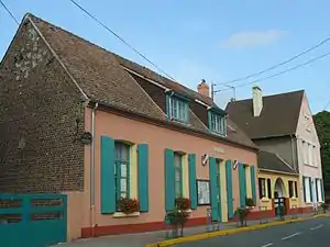 Rathaus (Mairie) von Hesdigneul-lès-Boulogne | ||

Geographie
Hesdigneul-lès-Boulogne liegt etwa neun Kilometer südsüdöstlich von Boulogne-sur-Mer. Die Gemeinde gehört zum Regionalen Naturpark Caps et Marais d’Opale.
Umgeben wird Hesdigneul-lès-Boulogne von den Nachbargemeinden Hesdin-l’Abbé im Norden und Nordosten, Carly im Osten, Verlincthun im Süden sowie Condette im Westen.
Bevölkerungsentwicklung
| Jahr | 1962 | 1968 | 1975 | 1982 | 1990 | 1999 | 2006 | 2013 |
| Einwohner | 581 | 620 | 621 | 621 | 618 | 579 | 671 | 657 |
| Quelle: Cassini und INSEE | ||||||||
Sehenswürdigkeiten
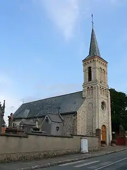
Kirche Saint-Éloi
- Kirche Saint-Éloi aus dem 19. Jahrhundert
- Mühle Saint-Jean von Moulinghen
This article is issued from Wikipedia. The text is licensed under Creative Commons - Attribution - Sharealike. The authors of the article are listed here. Additional terms may apply for the media files, click on images to show image meta data.