Baincthun
Baincthun (ndl.: "Baingten"[1]) ist eine französische Gemeinde mit 1294 Einwohnern (Stand 1. Januar 2019) im Département Pas-de-Calais in der Region Hauts-de-France. Sie gehört zum Arrondissement Boulogne-sur-Mer und zum Kanton Boulogne-sur-Mer-2
| Baincthun | ||
|---|---|---|

|
| |
| Staat | Frankreich | |
| Region | Hauts-de-France | |
| Département (Nr.) | Pas-de-Calais (62) | |
| Arrondissement | Boulogne-sur-Mer | |
| Kanton | Boulogne-sur-Mer-2 | |
| Gemeindeverband | Boulonnais | |
| Koordinaten | 50° 43′ N, 1° 41′ O | |
| Höhe | 22–133 m | |
| Fläche | 26,96 km² | |
| Einwohner | 1.294 (1. Januar 2019) | |
| Bevölkerungsdichte | 48 Einw./km² | |
| Postleitzahl | 62360 | |
| INSEE-Code | 62075 | |
Nachbargemeinden von Baincthun sind La Capelle-lès-Boulogne im Norden, Bellebrune (ndl.: "Bellebrone") im Nordosten, Crémarest und Wirwignes (ndl.: "Willewine") im Osten, Questrecques im Südosten, Carly im Süden, Hesdin-l‘Abbé im Südwesten, Echinghen (ndl.: "Essingem") und Isques (ndl.: "Iberge") im Westen sowie Saint-Martin-Boulogne im Nordwesten.
Die Gemeinde gehört zum Regionalen Naturpark Caps et Marais d’Opale.
Bevölkerungsentwicklung
| Jahr | 1962 | 1968 | 1975 | 1982 | 1990 | 1999 | 2007 |
| Einwohner | 1.049 | 1.082 | 1.071 | 1.087 | 1.147 | 1.206 | 1.364 |
Sehenswürdigkeiten
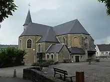
- Kirche Saint-Martin
- Schloss Ordre im Ortsteil Macquinghem (Monument historique)

Kirche Saint-Martin
Weblinks
Commons: Baincthun – Sammlung von Bildern, Videos und Audiodateien
Einzelnachweise
- De Nederlanden in Frankrijk, Jozef van Overstraeten, 1969
This article is issued from Wikipedia. The text is licensed under Creative Commons - Attribution - Sharealike. The authors of the article are listed here. Additional terms may apply for the media files, click on images to show image meta data.
