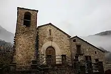
Foradada del Toscar
Foradada de Toscar ist eine spanische Gemeinde in der Provinz Huesca der Autonomen Gemeinschaft Aragonien. Sie liegt in der Comarca Ribagorza an der Straße N-260 von Campo nach Aínsa-Sobrarbe.
| Gemeinde Foradada del Toscar | |||
|---|---|---|---|
| Wappen | Karte von Spanien | ||
| ? Hilfe zu Wappen |
| ||
| Basisdaten | |||
| Autonome Gemeinschaft: | Aragonien | ||
| Provinz: | Huesca | ||
| Comarca: | Ribagorza | ||
| Koordinaten | 42° 25′ N, 0° 21′ O | ||
| Höhe: | 980 msnm | ||
| Fläche: | 106,25 km² | ||
| Einwohner: | 172 (1. Jan. 2019)[1] | ||
| Bevölkerungsdichte: | 1,62 Einw./km² | ||
| Postleitzahl: | 22452 | ||
| Gemeindenummer (INE): | 22111 | ||
| Verwaltung | |||
| Bürgermeister: | María Carmen Castillón Castillón (PSOE) | ||
| Website: | www.foradadadeltoscar.es | ||


Gemeindegebiet
Die Gemeinde umfasst die Ortschaften:
- Bacamorta
- Espluga
- Foradada del Toscar
- Lacort
- Las Colladas
- Lascorz
- Morillo de Liena
- Navarri
- Senz
- Víu
Sprachliche Zuordnung
In Campo wird Aragonesisch in der Variante des westlich gelegenen Valle de Fueva (aragonesisch: fován oder fovano) gesprochen.
Bevölkerungsentwicklung
| 1991 | 1996 | 2001 | 2004 |
|---|---|---|---|
| 272 | 260 | 259 | 213 |
Weblinks
- CAI Aragón-Foradada del Toscar (spanisch)
Einzelnachweise
- Cifras oficiales de población resultantes de la revisión del Padrón municipal a 1 de enero. Bevölkerungsstatistiken des Instituto Nacional de Estadística (Bevölkerungsfortschreibung).
Abiego | Abizanda | Adahuesca | Agüero | Aínsa-Sobrarbe | Aísa | Albalate de Cinca | Albalatillo | Albelda | Albero Alto | Albero Bajo | Alberuela de Tubo | Alcalá de Gurrea | Alcalá del Obispo | Alcampell | Alcolea de Cinca | Alcubierre | Alerre | Alfántega | Almudévar | Almunia de San Juan | Almuniente | Alquézar | Altorricón | Angüés | Ansó | Antillón | Aragüés del Puerto | Arén | Argavieso | Arguis | Ayerbe | Azanuy-Alins | Azara | Azlor | Baélls | Bailo | Baldellou | Ballobar | Banastás | Barbastro | Barbués | Barbuñales | Bárcabo | Belver de Cinca | Benabarre | Benasque | Beranuy | Berbegal | Bielsa | Bierge | Biescas | Binaced | Binéfar | Bisaurri | Biscarrués | Blecua y Torres | Boltaña | Bonansa | Borau | Broto | Caldearenas | Campo | Camporrells | Canal de Berdún | Candasnos | Canfranc | Capdesaso | Capella | Casbas de Huesca | Castejón de Monegros | Castejón de Sos | Castejón del Puente | Castelflorite | Castiello de Jaca | Castigaleu | Castillazuelo | Castillonroy | Chalamera | Chía | Chimillas | Colungo | El Grado | Esplús | Estada | Estadilla | Estopiñán del Castillo | Fago | Fanlo | Fiscal | Fonz | Foradada del Toscar | Fraga | Gistaín | Grañén | Graus | Gurrea de Gállego | Hoz de Jaca | Hoz y Costeán | Huerto | Huesca | Ibieca | Igriés | Ilche | Isábena | Jaca | Jasa | La Fueva | Labuerda | Laluenga | Lalueza | La Puebla de Castro | Lanaja | Laperdiguera | Lascellas-Ponzano | Lascuarre | Laspaúles | Las Peñas de Riglos | Laspuña | Loarre | Loporzano | Loscorrales | Lupiñén-Ortilla | Monesma y Cajigar | Monflorite-Lascasas | Montanuy | Monzón | Naval | Novales | Nueno | Ólvena | Ontiñena | Osso de Cinca | Palo | Panticosa | Peñalba | Peralta de Alcofea | Peralta de Calasanz | Peraltilla | Perarrúa | Pertusa | Piracés | Plan | Poleñino | Pozán de Vero | Puente de Montañana | Puente la Reina de Jaca | Puértolas | El Pueyo de Araguás | Pueyo de Santa Cruz | Quicena | Robres | Sabiñánigo | Sahún | Salas Altas | Salas Bajas | Salillas | Sallent de Gállego | San Esteban de Litera | San Juan de Plan | San Miguel del Cinca | Sangarrén | Santa Cilia | Santa Cruz de la Serós | Santa María de Dulcis | Santaliestra y San Quílez | Sariñena | Secastilla | Seira | Sena | Senés de Alcubierre | Sesa | Sesué | Siétamo | Sopeira | Sotonera (La) | Tamarite de Litera | Tardienta | Tella-Sin | Tierz | Tolva | Torla-Ordesa | Torralba de Aragón | Torre la Ribera | Torrente de Cinca | Torres de Alcanadre | Torres de Barbués | Tramaced | Valfarta | Valle de Bardají | Valle de Hecho | Valle de Lierp | Velilla de Cinca | Vencillón | Viacamp y Litera | Vicién | Villanova | Villanúa | Villanueva de Sigena | Yebra de Basa | Yésero | Zaidín