Communauté d’agglomération Valenciennes Métropole
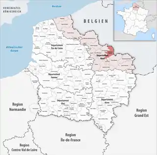
Die Communauté d’agglomération Valenciennes Métropole ist ein französischer Gemeindeverband mit der Rechtsform einer Communauté d’agglomération im Département Nord in der Region Hauts-de-France. Sie wurde am 22. Dezember 2000 gegründet und umfasst 35 Gemeinden. Der Verwaltungssitz liegt in der Stadt Valenciennes.[2]
| Communauté d’agglomération Valenciennes Métropole | |
| Region(en) | Hauts-de-France |
| Département(s) | Nord |
| Gründungsdatum | 22. Dezember 2000 |
| Verwaltungssitz | Valenciennes |
| Gemeinden | 35 |
| Präsident | Valérie Létard |
| SIREN-Nummer | 245 901 160 |
| Fläche | 263,77 km² |
| Einwohner | 192.550 (2019)[1] |
| Bevölkerungsdichte | 730 Einw./km² |
| Website | https://www.valenciennes-metropole.fr/ |
 Lage des Gemeindeverbandes in der Region Hauts-de-France | |
Mitgliedsgemeinden
| Gemeinde | Einwohner 1. Januar 2019 |
Fläche km² |
Dichte Einw./km² |
Code INSEE |
Postleitzahl |
|---|---|---|---|---|---|
| Anzin | 13.329 | 3,64 | 3.662 | 59014 | 59410 |
| Artres | 1.061 | 6,53 | 162 | 59019 | 59269 |
| Aubry-du-Hainaut | 1.705 | 4,29 | 397 | 59027 | 59494 |
| Aulnoy-lez-Valenciennes | 7.224 | 6,08 | 1.188 | 59032 | 59300 |
| Beuvrages | 6.809 | 3,02 | 2.255 | 59079 | 59192 |
| Bruay-sur-l’Escaut | 11.258 | 6,67 | 1.688 | 59112 | 59860 |
| Condé-sur-l’Escaut | 9.515 | 18,50 | 514 | 59153 | 59163 |
| Crespin | 4.495 | 9,98 | 450 | 59160 | 59154 |
| Curgies | 1.337 | 6,08 | 220 | 59166 | 59990 |
| Estreux | 959 | 5,31 | 181 | 59215 | 59990 |
| Famars | 2.545 | 4,81 | 529 | 59221 | 59300 |
| Fresnes-sur-Escaut | 7.499 | 11,73 | 639 | 59253 | 59970 |
| Hergnies | 4.433 | 10,78 | 411 | 59301 | 59199 |
| Maing | 4.066 | 11,65 | 349 | 59369 | 59233 |
| Marly | 12.083 | 8,05 | 1.501 | 59383 | 59770 |
| Monchaux-sur-Écaillon | 538 | 4,49 | 120 | 59407 | 59224 |
| Odomez | 924 | 4,87 | 190 | 59444 | 59970 |
| Onnaing | 8.789 | 12,99 | 677 | 59447 | 59264 |
| Petite-Forêt | 4.887 | 4,57 | 1.069 | 59459 | 59494 |
| Préseau | 1.993 | 6,36 | 313 | 59471 | 59990 |
| Prouvy | 2.220 | 4,43 | 501 | 59475 | 59121 |
| Quarouble | 3.077 | 12,36 | 249 | 59479 | 59243 |
| Quérénaing | 870 | 4,34 | 200 | 59480 | 59269 |
| Quiévrechain | 6.362 | 4,66 | 1.365 | 59484 | 59920 |
| Rombies-et-Marchipont | 760 | 4,80 | 158 | 59505 | 59990 |
| Rouvignies | 655 | 3,26 | 201 | 59515 | 59220 |
| Saint-Aybert | 348 | 4,17 | 83 | 59530 | 59163 |
| Saint-Saulve | 11.276 | 12,09 | 933 | 59544 | 59880 |
| Saultain | 2.492 | 6,45 | 386 | 59557 | 59990 |
| Sebourg | 1.974 | 14,17 | 139 | 59559 | 59990 |
| Thivencelle | 836 | 4,01 | 208 | 59591 | 59163 |
| Valenciennes | 43.229 | 13,93 | 3.103 | 59606 | 59300 |
| Verchain-Maugré | 1.073 | 9,64 | 111 | 59610 | 59227 |
| Vicq | 1.464 | 3,95 | 371 | 59613 | 59970 |
| Vieux-Condé | 10.465 | 11,11 | 942 | 59616 | 59690 |
| Communauté d’agglomération Valenciennes Métropole |
192.550 | 263,77 | 730 | – | – |
Quellen
- www.collectivites-locales.gouv.fr
- CA Valenciennes Métropole (SIREN: 245 901 160) in der Base nationale sur l’intercommunalité (BANATIC) des französischen Innenministeriums (französisch)
This article is issued from Wikipedia. The text is licensed under Creative Commons - Attribution - Sharealike. The authors of the article are listed here. Additional terms may apply for the media files, click on images to show image meta data.