Villacarriedo
Villacarriedo ist eine Gemeinde in der spanischen Autonomen Region Kantabrien. Villacarriedo, das administrative Zentrum und der bevölkerungsreichste Ort der Gemeinde, liegt 211 Meter über dem Meeresspiegel und 36 km südlich von Santander, der Hauptstadt Kantabriens.
| Gemeinde Villacarriedo | |||
|---|---|---|---|
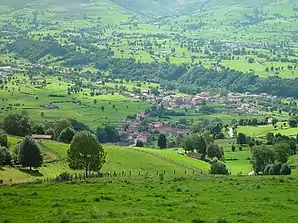 Landschaft | |||
| Wappen | Karte von Spanien | ||
.svg.png.webp) |
| ||
| Basisdaten | |||
| Autonome Gemeinschaft: | |||
| Koordinaten | 43° 14′ N, 3° 49′ W | ||
| Fläche: | 50,74 km² | ||
| Einwohner: | 1.612 (1. Jan. 2019)[1] | ||
| Bevölkerungsdichte: | 31,77 Einw./km² | ||
| Postleitzahl: | 39640 | ||
| Gemeindenummer (INE): | 39098 | ||
| Lage der Gemeinde | |||
_Mapa.svg.png.webp) | |||

Orte
- Abionzo
- Aloños
- Bárcena de Carriedo
- Pedroso
- Santibáñez
- Soto
- Tezanos
- Villacarriedo (Hauptort)
Bevölkerungsentwicklung
| 1842 | 1900 | 1950 | 1981 | 1991 | 2001 | 2011 |
|---|---|---|---|---|---|---|
| 1950 | 2584 | 2475 | 2233 | 2132 | 1755 | 1749 |
Weblinks
Einzelnachweise
- Cifras oficiales de población resultantes de la revisión del Padrón municipal a 1 de enero. Bevölkerungsstatistiken des Instituto Nacional de Estadística (Bevölkerungsfortschreibung).
Alfoz de Lloredo | Ampuero | Anievas | Arenas de Iguña | Argoños | Arnuero | Arredondo | El Astillero | Bárcena de Cicero | Bárcena de Pie de Concha | Bareyo | Cabezón de la Sal | Cabezón de Liébana | Cabuérniga | Camaleño | Camargo | Campoo de Enmedio | Campoo de Yuso | Cartes | Castañeda | Castro Urdiales | Cieza | Cillorigo de Liébana | Colindres | Comillas | Los Corrales de Buelna | Corvera de Toranzo | Entrambasaguas | Escalante | Guriezo | Hazas de Cesto | Hermandad de Campoo de Suso | Herrerías | Lamasón | Laredo | Liendo | Liérganes | Limpias | Luena | Marina de Cudeyo | Mazcuerras | Medio Cudeyo | Meruelo | Miengo | Miera | Molledo | Noja | Penagos | Peñarrubia | Pesaguero | Pesquera | Piélagos | Polaciones | Polanco | Potes | Puente Viesgo | Ramales de la Victoria | Rasines | Reinosa | Reocín | Ribamontán al Mar | Ribamontán al Monte | Rionansa | Riotuerto | Las Rozas de Valdearroyo | Ruente | Ruesga | Ruiloba | San Felices de Buelna | San Miguel de Aguayo | San Pedro del Romeral | San Roque de Riomiera | San Vicente de la Barquera | Santa Cruz de Bezana | Santa María de Cayón | Santander | Santillana del Mar | Santiurde de Reinosa | Santiurde de Toranzo | Santoña | Saro | Selaya | Soba | Solórzano | Suances | Los Tojos | Torrelavega | Tresviso | Tudanca | Udías | Val de San Vicente | Valdáliga | Valdeolea | Valdeprado del Río | Valderredible | Valle de Villaverde | Vega de Liébana | Vega de Pas | Villacarriedo | Villaescusa | Villafufre | Voto