Valfleury
Valfleury ist eine französische Gemeinde mit 707 Einwohnern (Stand: 1. Januar 2019) im Département Loire in der Region Auvergne-Rhône-Alpes. Sie gehört zum Arrondissement Saint-Étienne und zum Kanton Sorbiers. Die Einwohner werden Cellieutaires genannt.
| Valfleury | ||
|---|---|---|
| ||
| Staat | Frankreich | |
| Region | Auvergne-Rhône-Alpes | |
| Département (Nr.) | Loire (42) | |
| Arrondissement | Saint-Étienne | |
| Kanton | Sorbiers | |
| Gemeindeverband | Saint-Étienne Métropole | |
| Koordinaten | 45° 31′ N, 4° 30′ O | |
| Höhe | 359–820 m | |
| Fläche | 8,84 km² | |
| Einwohner | 707 (1. Januar 2019) | |
| Bevölkerungsdichte | 80 Einw./km² | |
| Postleitzahl | 42320 | |
| INSEE-Code | 42320 | |
| Website | http://www.valfleury.fr/ | |
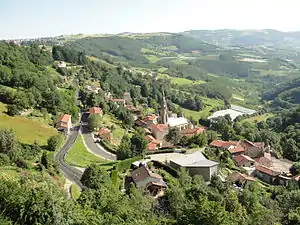 Blick auf Valfleury | ||

Geographie
Valfleury liegt etwa 14 Kilometer nordöstlich von Saint-Étienne. Umgeben wird Valfleury von den Nachbargemeinden Saint-Romain-en-Jarez im Norden und Nordosten, Chagnon im Osten und Südosten, Cellieu im Süden und Südosten sowie Saint-Christo-en-Jarez im Westen.
Bevölkerungsentwicklung
| Jahr | 1962 | 1968 | 1975 | 1982 | 1990 | 1999 | 2006 | 2017 |
|---|---|---|---|---|---|---|---|---|
| Einwohner | 373 | 367 | 370 | 437 | 486 | 516 | 584 | 708 |
| Quellen: Cassini und INSEE | ||||||||
Sehenswürdigkeiten
- Kirche Notre-Dame
- Schloss Lachal
- Türme (u. a. Uhrenturm)
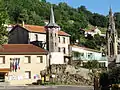 Rathaus (mairie)
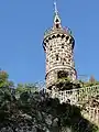 Turm
Turm
Weblinks
Commons: Valfleury – Sammlung von Bildern, Videos und Audiodateien
This article is issued from Wikipedia. The text is licensed under Creative Commons - Attribution - Sharealike. The authors of the article are listed here. Additional terms may apply for the media files, click on images to show image meta data.