Usclades-et-Rieutord
Usclades-et-Rieutord ist eine französische Gemeinde im Département Ardèche in der Region Auvergne-Rhône-Alpes. Sie gehört zum Kanton Haute-Ardèche und zum Arrondissement Largentière. Sie grenzt im Norden an Sainte-Eulalie, im Nordosten an Sagnes-et-Goudoulet, im Südosten an Burzet, im Süden an Montpezat-sous-Bauzon, im Südwesten an Saint-Cirgues-en-Montagne und im Westen an Cros-de-Géorand.
| Usclades-et-Rieutord | ||
|---|---|---|
| ||
| Staat | Frankreich | |
| Region | Auvergne-Rhône-Alpes | |
| Département (Nr.) | Ardèche (07) | |
| Arrondissement | Largentière | |
| Kanton | Haute-Ardèche | |
| Gemeindeverband | Montagne d’Ardèche | |
| Koordinaten | 44° 47′ N, 4° 10′ O | |
| Höhe | 1112–1445 m | |
| Fläche | 12,53 km² | |
| Einwohner | 117 (1. Januar 2019) | |
| Bevölkerungsdichte | 9 Einw./km² | |
| Postleitzahl | 07510 | |
| INSEE-Code | 07326 | |

Infrastruktur
Die vormalige Route nationale 536 und heutige Départementsstraße D122 führt über Usclades-et-Rieutord.
Bevölkerungsentwicklung
| Jahr | 1962 | 1968 | 1975 | 1982 | 1990 | 1999 | 2008 | 2014 |
|---|---|---|---|---|---|---|---|---|
| Einwohner | 206 | 169 | 131 | 115 | 123 | 102 | 122 | 128 |
| Quellen: Cassini und INSEE | ||||||||
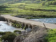
Brücke über die Loire
This article is issued from Wikipedia. The text is licensed under Creative Commons - Attribution - Sharealike. The authors of the article are listed here. Additional terms may apply for the media files, click on images to show image meta data.